
Sourdun
| Sourdun | ||
|---|---|---|
|
||
| region | Île-de-France | |
| Department | Seine-et-Marne | |
| Arrondissement | Provins | |
| Canton | Provins | |
| Community association | Provinois | |
| Coordinates | 48 ° 32 ' N , 3 ° 21' E | |
| height | 92-173 m | |
| surface | 23.33 km 2 | |
| Residents | 1,484 (January 1, 2017) | |
| Population density | 64 inhabitants / km 2 | |
| Post Code | 77171 | |
| INSEE code | 77459 | |
 Town Hall (Mairie) of Sourdun |
||

Sourdun is a French commune with 1,484 inhabitants (as of January 1 2017) in the department of Seine-et-Marne in the region Ile-de-France . It belongs to the Arrondissement of Provins and the Canton of Provins (until 2015: Canton Villiers-Saint-Georges ). The inhabitants are called Sourdunois .
geography
Sourdun is about 60 kilometers east-southeast of Paris . The Voulzie delimits the municipality in the north and in the northwest. Sourdun is surrounded by the neighboring municipalities of Saint-Brice in the north and north-west, Léchelle in the north and north-east, Chalautre-la-Grande in the east, Le Mériot in the south-east, Melz-sur-Seine in the south, Hermé in the south and south-west, Soisy-Bouy in the south-west, Chalautre-la-Petite in the west and Provins in the north-west.
Population development
| year | 1962 | 1968 | 1975 | 1982 | 1990 | 1999 | 2006 | 2013 |
| Residents | 676 | 731 | 777 | 979 | 1,114 | 1,232 | 1,463 | 1,465 |
| Source: Cassini and INSEE | ||||||||
Attractions
See also: List of the Monuments historiques in Sourdun
- Saint-Martin church from the 12th / 13th centuries Century, alterations from the 16th century, since 1971 Monument historique
- Saint-Hubert chapel
- Town hall, former priory from the 16./17. Century, Monument historique since 1971
- Ormurion Castle
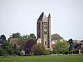
Saint Martin Church

Ormurion Castle


Trivia
The 2nd hussar regiment of the French army is stationed in Sourdun.
literature
- Le Patrimoine des Communes de la Seine-et-Marne. Flohic Editions, Volume 2, Paris 2001, ISBN 2-84234-100-7 , pp. 1492-1493.