Lescherolles
| Lescherolles | ||
|---|---|---|
|
|
||
| region | Île-de-France | |
| Department | Seine-et-Marne | |
| Arrondissement | Provins | |
| Canton | Coulommiers | |
| Community association | Deux Morin | |
| Coordinates | 48 ° 46 ′ N , 3 ° 21 ′ E | |
| height | 116-192 m | |
| surface | 11.01 km 2 | |
| Residents | 463 (January 1, 2017) | |
| Population density | 42 inhabitants / km 2 | |
| Post Code | 77320 | |
| INSEE code | 77247 | |
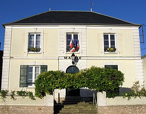
 Town Hall (Mairie) |
||
Lescherolles is a French municipality with 463 inhabitants (at January 1, 2017) in the department of Seine-et-Marne in the region Ile-de-France . It belongs to the Arrondissement Provins and the Canton of Coulommiers . The inhabitants are called Lescherollais (es) .
geography
The municipality of Lescherolles is located about 4.5 kilometers southeast of La Ferté-Gaucher , 25 kilometers east of Coulommiers , 22 kilometers north of Provins and 80 kilometers east of Paris .
Population development
| year | 1936 | 1946 | 1954 | 1962 | 1968 | 1975 | 1982 | 1990 | 1999 | 2006 | 2014 |
| Residents | 255 | 226 | 280 | 273 | 291 | 264 | 300 | 372 | 418 | 462 | 482 |
Attractions
See also: List of the Monuments historiques in Lescherolles
- Parish Church of Notre-Dame-de-la-Nativité ( Monument historique )
- lock
literature
- Le Patrimoine des Communes de la Seine-et-Marne. Flohic Editions, Volume 1, Paris 2001, ISBN 2-84234-100-7 , pp. 517-518.
Web links
Commons : Lescherolles - collection of images, videos and audio files
Individual evidence
- ↑ Profile of Lescherolles ( French ) Retrieved on August 4, 2014.

