
Noisy Rudignon
| Noisy Rudignon | ||
|---|---|---|
|
||
| region | Île-de-France | |
| Department | Seine-et-Marne | |
| Arrondissement | Provins | |
| Canton | Nemours | |
| Community association | Pays de Montereau | |
| Coordinates | 48 ° 20 ′ N , 2 ° 56 ′ E | |
| height | 55-126 m | |
| surface | 4.16 km 2 | |
| Residents | 610 (January 1, 2017) | |
| Population density | 147 inhabitants / km 2 | |
| Post Code | 77940 | |
| INSEE code | 77338 | |
| Website | Homepage | |
 Map of Noisy-Rudignon |
||

Noisy-Rudignon is a French municipality with 610 inhabitants (as of January 1 2017) in the department of Seine-et-Marne in the region Ile-de-France . It belongs to the Arrondissement Provins and the Canton of Nemours . The inhabitants are called Nantelliens or Nantelliennes .
geography
Noisy-Rudignon is six and a half kilometers south of Montereau-Fault-Yonne .
| Ville-Saint-Jacques | Varennes-sur-Seine | Esmans |
.svg)
|
||
| Dormelles | Flagy | Thoury-Férottes |
Attractions
- Church of Sainte-Barbe (see also: List of Monuments historiques in Noisy-Rudignon )

town hall
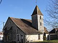
Sainte-Barbe church


literature
- Le Patrimoine des Communes de la Seine-et-Marne . Flohic Editions, Volume 1, Paris 2001, ISBN 2-84234-100-7 , pp. 681-682.
Web links
Commons : Noisy-Rudignon - Collection of images, videos and audio files