
Flagy (Seine-et-Marne)
| Flagy | ||
|---|---|---|
.svg)
|
|
|
| region | Île-de-France | |
| Department | Seine-et-Marne | |
| Arrondissement | Fontainebleau | |
| Canton | Nemours | |
| Community association | Moret Seine et Loing | |
| Coordinates | 48 ° 19 ′ N , 2 ° 55 ′ E | |
| height | 69-151 m | |
| surface | 7.21 km 2 | |
| Residents | 649 (January 1, 2017) | |
| Population density | 90 inhabitants / km 2 | |
| Post Code | 77940 | |
| INSEE code | 77184 | |
 Town Hall ( Mairie ) |
||

Flagy is a French municipality with 649 inhabitants (as of January 1 2017) in the department of Seine-et-Marne in the region Ile-de-France . It belongs to the Arrondissement of Fontainebleau and the Canton of Nemours .
geography
Flagy is ten kilometers south of Montereau-Fault-Yonne .
| Noisy Rudignon | ||
| Dormelles |
.svg)
|
|
| Villemaréchal | Saint-Ange-le-Viel | Thoury-Férottes |
Attractions
See also: List of Monuments historiques in Flagy (Seine-et-Marne)
- Church of the Assumption
- 19th century wash house
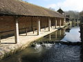
Wash house ( lavoir )
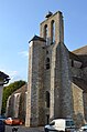
Church of the Assumption


literature
- Le Patrimoine des Communes de la Seine-et-Marne . Flohic Editions, Volume 1, Paris 2001, ISBN 2-84234-100-7 , pp. 673-675.
Web links
Commons : Flagy - collection of images, videos and audio files