
Chaintreaux
| Chaintreaux | ||
|---|---|---|
|
||
| region | Île-de-France | |
| Department | Seine-et-Marne | |
| Arrondissement | Fontainebleau | |
| Canton | Nemours | |
| Community association | Gâtinais-Val de Loing | |
| Coordinates | 48 ° 12 ′ N , 2 ° 49 ′ E | |
| height | 88-133 m | |
| surface | 23.92 km 2 | |
| Residents | 909 (January 1, 2017) | |
| Population density | 38 inhabitants / km 2 | |
| Post Code | 77460 | |
| INSEE code | 77071 | |
 Mairie Chaintreaux |
||

Chaintreaux is a French municipality with 909 inhabitants (as of January 1 2017) in the department of Seine-et-Marne in the region Ile-de-France . It belongs to the Arrondissement of Fontainebleau and the Canton of Nemours .
geography
Chaintreaux is five kilometers northwest of Égreville and seven kilometers east of Souppes-sur-Loing .
| Poligny | Remauville | Lorrez-le-Bocage-Préaux |
| Souppes-sur-Loing |
.svg)
|
Égreville |
| Dordives | Bransles |
Attractions
See also: List of Monuments historiques in Chaintreaux
- Church of St. Peter and Paul

Saint-Eutrope church in the Lagerville district
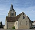
Church of St. Peter and Paul

War memorial


literature
- Le Patrimoine des Communes de la Seine-et-Marne . Flohic Editions, Volume 1, Paris 2001, ISBN 2-84234-100-7 , pp. 191-193.
Web links
Commons : Chaintreaux - collection of images, videos and audio files
- Chaintreaux at annuaire-mairie.fr (French)