
Boissy-aux-Cailles
| Boissy-aux-Cailles | ||
|---|---|---|
|
||
| region | Île-de-France | |
| Department | Seine-et-Marne | |
| Arrondissement | Fontainebleau | |
| Canton | Fontainebleau | |
| Community association | Pays de Fontainebleau | |
| Coordinates | 48 ° 19 ′ N , 2 ° 30 ′ E | |
| height | 71-123 m | |
| surface | 16.10 km 2 | |
| Residents | 290 (January 1, 2017) | |
| Population density | 18 inhabitants / km 2 | |
| Post Code | 77760 | |
| INSEE code | 77041 | |
| Website | https://www.boissyauxcailles.fr/ | |

Boissy-aux-Cailles is a French commune with 290 inhabitants (as of January 1, 2017) in the Seine-et-Marne department ( Île-de-France region ). Boissy-aux-Cailles belongs to the Arrondissement of Fontainebleau and the Canton of Fontainebleau .
location
The municipality is located in the Gâtinais français Regional Nature Park .
Neighboring communities are:
| Nanteau-sur-Essonne | Tousson , Le Vaudoué | La Chapelle-la-Reine |
| Buthiers |
.svg)
|
|
| Amponville |
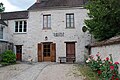
town hall
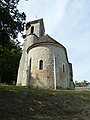
Saint Martin Church

Boissy around 1900


Attractions
See: List of the Monuments historiques in Boissy-aux-Cailles
literature
- Le Patrimoine des Communes de la Seine-et-Marne . Flohic Editions, Volume 1, Paris 2001, ISBN 2-84234-100-7 , pp. 136-137.
Web links
Commons : Boissy-aux-Cailles - Collection of images, videos and audio files
- Boissise-le-Roi at annuaire-mairie.fr (French)