
Grez-sur-Loing
| Grez-sur-Loing | ||
|---|---|---|

|
|
|
| region | Île-de-France | |
| Department | Seine-et-Marne | |
| Arrondissement | Fontainebleau | |
| Canton | Nemours | |
| Community association | Pays de Nemours | |
| Coordinates | 48 ° 19 ′ N , 2 ° 41 ′ E | |
| height | 52-85 m | |
| surface | 12.97 km 2 | |
| Residents | 1,414 (January 1, 2017) | |
| Population density | 109 inhabitants / km 2 | |
| Post Code | 77880 | |
| INSEE code | 77216 | |
 Town Hall ( Mairie ) |
||

Grez-sur-Loing (formerly Grès-en-Gâtinais ) is a French municipality with 1414 inhabitants (at January 1, 2017) in the department of Seine-et-Marne in the region Ile-de-France . It belongs to the Arrondissement of Fontainebleau and the Canton of Nemours . The districts are Hulay and L'Auberge, neighboring communities Montigny-sur-Loing , Bourron-Marlotte and Montcourt-Fromonville .
history
Grez was of great importance in the 13th century as part of the Blanka morning gift of Castile . On the territory of the commune, on the way from Beauvais-en-Gâtinais to Villiers-sous-Grez, there was a Commanderie of the Knights Templar , of which only a few cellars and the well can be found today. In 1358 the place was burned down as part of the Hundred Years War .
Population development
- 1962: 727
- 1968: 951
- 1975: 1071
- 1982: 1045
- 1990: 1104
- 1999: 1277
Attractions
See also: List of Monuments historiques in Grez-sur-Loing
- Notre-Dame et Saint-Laurent church (12th century) with graves from the 16th century
- Tour de Ganne (1127)
- Pont de Grez (12th / 14th century), bridge over the Loing

Tour de Ganne

Notre-Dame et Saint-Laurent church
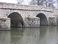
bridge


Personalities
- Luise of Savoy died in Grez in 1531
- Laure de Berny, Honoré de Balzac's lover , died in Grez in 1836
- Carl Larsson , painter, lived in Grez
- Jelka Rosen (1868–1935), German painter, wife of Frederick Delius, lived in Grez
- Frederick Delius , composer, lived in Grez
- Jean-Baptiste Camille Corot painted the Pont de Grez
- Jean-Baptiste-Moïse Jollivet , Maire 1790–1791
literature
- Le Patrimoine des Communes de la Seine-et-Marne . Flohic Editions, Volume 2, Paris 2001, ISBN 2-84234-100-7 , pp. 1144-1146.