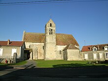
Amponville
| Amponville | ||
|---|---|---|
|
|
||
| region | Île-de-France | |
| Department | Seine-et-Marne | |
| Arrondissement | Fontainebleau | |
| Canton | Fontainebleau | |
| Community association | Pays de Nemours | |
| Coordinates | 48 ° 17 ' N , 2 ° 32' E | |
| height | 103-122 m | |
| surface | 12.30 km 2 | |
| Residents | 351 (January 1, 2017) | |
| Population density | 29 inhabitants / km 2 | |
| Post Code | 77760 | |
| INSEE code | 77003 | |
 Mairie (Town Hall) |
||
Amponville ![]() is a French municipality with 351 inhabitants (at January 1, 2017) in the Seine-et-Marne in the region Ile-de-France . It belongs to the Arrondissement of Fontainebleau and the Canton of Fontainebleau . The inhabitants call themselves Amponvillois .
is a French municipality with 351 inhabitants (at January 1, 2017) in the Seine-et-Marne in the region Ile-de-France . It belongs to the Arrondissement of Fontainebleau and the Canton of Fontainebleau . The inhabitants call themselves Amponvillois .
geography
The place is 67 kilometers southeast of Paris. The next major city is Nemours, 14 kilometers to the east . The municipality is located in the Gâtinais français Regional Nature Park .
The hamlet of Jacqueville , located north of Amponville, belongs to the municipality .
Amponville is surrounded by the eight neighboring communities:
| Boissy-aux-Cailles | La Chapelle-la-Reine | |
| Buthiers |

|
Larchant |
| Rumont | Fromont Burcy | Guercheville |
history
Amponville is first documented in 1113. From the 12th century until the French Revolution , the place belonged to the Abbey of Saint-Victor in Paris, which had a priory built in Amponville .
Population development
| year | 1962 | 1968 | 1975 | 1982 | 1990 | 1999 | 2007 |
| Residents | 262 | 246 | 219 | 242 | 271 | 301 | 363 |
Attractions
- Notre-Dame-de-l'Assomption church in Amponville, built in the 12th / 13th centuries. Century ( Monument historique )
- Notre-Dame-de-la-Nativité-et-Saint-Séverin church in Jacqueville, built in the 12th and 14th centuries
literature
- Le Patrimoine des Communes de la Seine-et-Marne . Flohic Editions, Volume 1, Paris 2001, ISBN 2-84234-100-7 , pp. 132-135.
Web links
- Amponville at annuaire-mairie.fr (French)

