
Garentreville
| Garentreville | ||
|---|---|---|
|
||
| region | Île-de-France | |
| Department | Seine-et-Marne | |
| Arrondissement | Fontainebleau | |
| Canton | Nemours | |
| Community association | Pays de Nemours | |
| Coordinates | 48 ° 14 ' N , 2 ° 33' E | |
| height | 107-144 m | |
| surface | 6.35 km 2 | |
| Residents | 114 (January 1, 2017) | |
| Population density | 18 inhabitants / km 2 | |
| Post Code | 77890 | |
| INSEE code | 77200 | |

Garentreville is a French commune in the Seine-et-Marne in the Ile-de-France . It belongs to the canton of Nemours in the Arrondissement of Fontainebleau . The residents call themselves Garentrevillois .
geography
The parish is bordered to the north by Guercheville , to the east by Chevrainvilliers , to the southeast by Aufferville , to the south by Obsonville and to the west by Burcy . Garentreville is located in the Gâtinais français Regional Nature Park and is characterized by agriculture.
Population development
| year | 1962 | 1968 | 1975 | 1982 | 1990 | 1999 | 2008 | 2013 |
|---|---|---|---|---|---|---|---|---|
| Residents | 103 | 103 | 82 | 74 | 85 | 79 | 101 | 106 |
Attractions
- Water tower
- Saint-Martin church, built in the 16th century

Water tower

Saint Martin Church
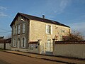
Mairie (Town Hall)


literature
- Le Patrimoine des Communes de la Seine-et-Marne . Flohic Editions, Volume 2, Paris 2001, ISBN 2-84234-100-7 , pp. 1140-1141.
Web links
Commons : Garentreville - Collection of Images, Videos and Audio Files