
Égreville
| Égreville | ||
|---|---|---|

|
|
|
| region | Île-de-France | |
| Department | Seine-et-Marne | |
| Arrondissement | Fontainebleau | |
| Canton | Nemours | |
| Community association | Gâtinais-Val de Loing | |
| Coordinates | 48 ° 11 ′ N , 2 ° 52 ′ E | |
| height | 107-141 m | |
| surface | 31.84 km 2 | |
| Residents | 2,150 (January 1, 2017) | |
| Population density | 68 inhabitants / km 2 | |
| Post Code | 77620 | |
| INSEE code | 77168 | |
| Website | http://www.egreville.fr/ | |
 Town Hall ( Mairie ) |
||

Égreville is a French commune with 2,150 inhabitants (at January 1, 2017) in the department of Seine-et-Marne in the region Ile-de-France . It belongs to the Arrondissement of Fontainebleau and the Canton of Nemours . Neighboring municipalities of Égreville are Paley in the north, Lorrez-le-Bocage-Préaux , Vaux-sur-Lunain and Villebéon in the northeast, Jouy and Le Bignon-Mirabeau in the southeast, Chevry-sous-le-Bignon in the south, and BranslesChevannes in the southwest, and Chaintreaux and Remauville in the northwest.
Population development
| year | 1962 | 1968 | 1975 | 1982 | 1990 | 1999 | 2010 |
| Residents | 1311 | 1212 | 1224 | 1342 | 1623 | 1841 | 2200 |
Attractions
See also: List of Monuments historiques in Égreville
- Jardin-musée départemental Bourdelle , since the 1960s
- Market hall , built at the end of the 15th century ( Monument historique )
- Saint-Martin church, built in the 13th to 17th centuries (Monument historique)
- 12th century castle
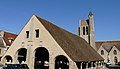
Market hall and church

Saint Martin Church

Jardin museum


Personalities
- Jules Massenet (1842–1912), composer, buried in Égreville
literature
- Le Patrimoine des Communes de la Seine-et-Marne. Flohic Editions, Volume 1, Paris 2001, ISBN 2-84234-100-7 , pp. 671-673.
Web links
Commons : Égreville - collection of images, videos and audio files