
Tousson
| Tousson | ||
|---|---|---|
|
||
| region | Île-de-France | |
| Department | Seine-et-Marne | |
| Arrondissement | Fontainebleau | |
| Canton | Fontainebleau | |
| Community association | Pays de Fontainebleau | |
| Coordinates | 48 ° 21 ′ N , 2 ° 28 ′ E | |
| height | 104-133 m | |
| surface | 13.24 km 2 | |
| Residents | 391 (January 1, 2017) | |
| Population density | 30 inhabitants / km 2 | |
| Post Code | 77123 | |
| INSEE code | 77471 | |
 Mairie from Tousson |
||

Tousson is a French commune in the Seine-et-Marne in the region Ile-de-France . It belongs to the canton of Fontainebleau in the arrondissement of the same name .
geography
The municipality is located in the Gâtinais français Regional Nature Park . It is bordered to the northwest by Oncy-sur-École , to the northeast by Noisy-sur-École , to the southeast by Le Vaudoué , to the south by Boissy-aux-Cailles , to the southwest by Nanteau-sur-Essonne and to the west by Buno-Bonnevaux .
Population development
| year | 1962 | 1968 | 1975 | 1982 | 1990 | 1999 | 2008 | 2014 |
|---|---|---|---|---|---|---|---|---|
| Residents | 370 | 353 | 302 | 292 | 334 | 378 | 382 | 378 |
Attractions
See also: List of Monuments historiques in Tousson
- Water tower
- Church of the Birth of Our Lady ( Église Notre-Dame-de-la-Nativité )
- La cour des rois
- Menhir de la Croix Saint-Jacques

Water tower
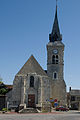
Church of the Birth of Mary

La cour des rois

Menhir de la Croix Saint-Jacques


literature
- Le Patrimoine des Communes de la Seine-et-Marne . Flohic Editions, Volume 1, Paris 2001, ISBN 2-84234-100-7 , pp. 167-169.
Web links
Commons : Tousson - collection of images, videos and audio files