
Le Vaudoué
| Le Vaudoué | ||
|---|---|---|
.svg)
|
|
|
| region | Île-de-France | |
| Department | Seine-et-Marne | |
| Arrondissement | Fontainebleau | |
| Canton | Fontainebleau | |
| Community association | Pays de Fontainebleau | |
| Coordinates | 48 ° 21 ' N , 2 ° 31' E | |
| height | 66-123 m | |
| surface | 17.16 km 2 | |
| Residents | 739 (January 1, 2017) | |
| Population density | 43 inhabitants / km 2 | |
| Post Code | 77123 | |
| INSEE code | 77485 | |
 Mairie Le Vaudoué |
||

Le Vaudoué is a French municipality with 739 inhabitants (as of January 1 2017) in the department of Seine-et-Marne in the region Ile-de-France . It belongs to the Arrondissement of Fontainebleau and the Canton of Fontainebleau .
geography
The municipality is located in the Gâtinais français Regional Nature Park .
| Noisy-sur-École | ||
| Tousson |
.svg)
|
Achères-la-Forêt |
| Boissy-aux-Cailles | La Chapelle-la-Reine |
Attractions
See also: List of Monuments historiques in Le Vaudoué
- Saint-Loup church

War memorial
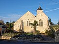
Saint-Loup church


literature
- Le Patrimoine des Communes de la Seine-et-Marne . Flohic Editions, Volume 1, Paris 2001, ISBN 2-84234-100-7 , pp. 173-175.
Web links
Commons : Le Vaudoué - collection of images, videos and audio files