Saint-Sauveur-sur-École
| Saint-Sauveur-sur-École | ||
|---|---|---|

|
|
|
| region | Île-de-France | |
| Department | Seine-et-Marne | |
| Arrondissement | Fontainebleau | |
| Canton | Fontainebleau | |
| Community association | Pays de Fontainebleau | |
| Coordinates | 48 ° 30 ' N , 2 ° 33' E | |
| height | 42-83 m | |
| surface | 7.32 km 2 | |
| Residents | 1,122 (January 1, 2017) | |
| Population density | 153 inhabitants / km 2 | |
| Post Code | 77930 | |
| INSEE code | 77435 | |
| Website | http://www.saintsauveursurecole.fr/ | |
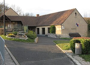
 Town hall (Mairie) of Saint-Sauveur-sur-École |
||
Saint-Sauveur-sur-École is a commune with 1,122 inhabitants (as of January 1 2017) in the department of Seine-et-Marne in the region Ile-de-France . It belongs to the arrondissement of Fontainebleau and the canton of Fontainebleau (until 2015: canton of Perthes ). The inhabitants are called Saint-Salvatoriens .
geography
Saint-Sauveur-sur-École is located about 43 kilometers south-southeast of Paris and about 15 kilometers northwest of Fontainebleau am École . The municipality is located in the Gâtinais français Regional Nature Park . Saint-Sauveur-sur-École is surrounded by Saint-Fargeau-Ponthierry and Pringy in the north, Boissise-le-Roi in the east, Perthes in the south, Saint-Germain-sur-École and Soisy-sur-École in the southwest and Nainville- les-Roches to the west.
The A6 car route runs along the western edge of the municipality .
Population development
| 1962 | 1968 | 1975 | 1982 | 1990 | 1999 | 2006 | 2013 |
|---|---|---|---|---|---|---|---|
| 331 | 289 | 445 | 775 | 968 | 1,048 | 1,079 | 1.109 |
| Source: Cassini and INSEE | |||||||
Attractions
- Saint-Sauveur church from the 13th century, alterations from the 17th century
- La Fosse old watermill
Personalities
- Marcel Arland (1899–1986), essayist and literary critic
literature
- Le Patrimoine des Communes de la Seine-et-Marne. Flohic Editions, Volume 2, Paris 2001, ISBN 2-84234-100-7 , pp. 1226-1227.

