
Soisy-sur-École
| Soisy-sur-École | ||
|---|---|---|
.svg)
|
|
|
| region | Île-de-France | |
| Department | Essonne | |
| Arrondissement | Evry | |
| Canton | Mennecy | |
| Community association | Deux Vallées | |
| Coordinates | 48 ° 28 ′ N , 2 ° 30 ′ E | |
| height | 48-144 m | |
| surface | 11.52 km 2 | |
| Residents | 1,269 (January 1, 2017) | |
| Population density | 110 inhabitants / km 2 | |
| Post Code | 91840 | |
| INSEE code | 91599 | |
| Website | http://soisysurecole.fr/ | |
 Town hall (Mairie) of Soisy-sur-École |
||

Soisy-sur-École is a French commune with a population of 763 (as at 1st January 2017) in the department of Essonne in the region of Ile-de-France . It belongs to the arrondissement Évry and the canton Mennecy (until 2015: canton Milly-la-Forêt ). The inhabitants are called Soiséens .
geography
Soisy-sur-École is located about 43 kilometers south-southeast of Paris on the École River . The municipality is located in the Gâtinais français Regional Nature Park . Soisy-sur-École is surrounded by the neighboring communities of Champcueil in the north and north-west, Nainville-les-Roches in the north, Saint-Sauveur-sur-École in the north-east, Saint-Germain-sur-École in the east, Cély in the south-east, Dannemois in the South, Videlles in the southwest and Mondeville in the west.
Population development
| 1962 | 1968 | 1975 | 1982 | 1990 | 1999 | 2006 | 2013 |
|---|---|---|---|---|---|---|---|
| 635 | 608 | 830 | 1,054 | 1.311 | 1,321 | 1,358 | 1,367 |
| Source: Cassini and INSEE | |||||||
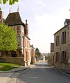
Attractions
See also: List of Monuments historiques in Soisy-sur-École
- Saint-Aignan church, originally from the 10th century
- Rectory

Saint-Aignan church
Rectory


literature
- Le Patrimoine des Communes de l'Essonne. Flohic Éditions, Volume 2, Paris 2001, ISBN 2-84234-126-0 , pp. 759-763.