Corn
| Corn | ||
|---|---|---|

|
|
|
| region | Île-de-France | |
| Department | Essonne | |
| Arrondissement | Evry | |
| Canton | Mennecy | |
| Community association | Deux Vallées | |
| Coordinates | 48 ° 24 ' N , 2 ° 23' E | |
| height | 59-147 m | |
| surface | 21.58 km 2 | |
| Residents | 2,719 (January 1, 2017) | |
| Population density | 126 inhabitants / km 2 | |
| Post Code | 91720 | |
| INSEE code | 91359 | |
| Website | http://www.maisse.fr/ | |
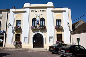
 Maisse Town Hall |
||
Maisse is a French commune with 2,719 inhabitants (as of January 1 2017) in the department of Essonne in the region of Ile-de-France . It belongs to the Arrondissement of Évry and the Canton of Mennecy . The inhabitants are called Maissois .
geography
Maisse is located about 52 kilometers south of Paris on the Essonne River . The municipality is located in the Gâtinais français Regional Nature Park . Maisse is surrounded by the neighboring communities Courdimanche-sur-Essonne in the north, Milly-la-Forêt in the east, Buno-Bonnevaux in the southeast, Gironville-sur-Essonne in the south and Valpuiseaux in the west.
Population development
| 1962 | 1968 | 1975 | 1982 | 1990 | 1999 | 2006 | 2012 |
|---|---|---|---|---|---|---|---|
| 1,402 | 1,385 | 1,592 | 1,945 | 2,495 | 2,622 | 2,647 | 2,703 |
Attractions
See also: List of Monuments historiques in Maisse
- Saint-Médard church, a historic monument since 1926
- Cave with primeval paintings, monument historique since 1955
- Cemetery cross, monument historique since 1965
- Water tower
Community partnerships
A partnership has existed with the German municipality of Morsbach in North Rhine-Westphalia since 1970.
literature
- Le Patrimoine des Communes de l'Essonne. Flohic Éditions, Volume 2, Paris 2001, ISBN 2-84234-126-0 , pp. 730-735.


