
Recloses
| Recloses | ||
|---|---|---|

|
|
|
| region | Île-de-France | |
| Department | Seine-et-Marne | |
| Arrondissement | Fontainebleau | |
| Canton | Fontainebleau | |
| Community association | Pays de Fontainebleau | |
| Coordinates | 48 ° 21 ′ N , 2 ° 39 ′ E | |
| height | 72-133 m | |
| surface | 9.35 km 2 | |
| Residents | 635 (January 1, 2017) | |
| Population density | 68 inhabitants / km 2 | |
| Post Code | 77760 | |
| INSEE code | 77386 | |

Recloses is a French commune in the Seine-et-Marne in the region Ile-de-France . It belongs to the canton of Fontainebleau (until 2015 canton of La Chapelle-la-Reine ) in the arrondissement of the same name . The residents call themselves reclosoits or reclosoites.
geography
The municipality is located in the Gâtinais français Regional Nature Park . It borders on Fontainebleau to the north, Bourron-Marlotte to the east, Grez-sur-Loing to the south-east, Villiers-sous-Grez to the south, La Chapelle-la-Reine to the south-west and Ury to the west .
| Fontainebleau | ||
| Ury |
.svg)
|
Bourron marlotte |
| La Chapelle-la-Reine | Villiers-sous-Grez | Grez-sur-Loing |
In addition to the main settlement, Reclose also includes the hamlets of Cumiers and La Vignette.
Population development
| year | 1962 | 1968 | 1975 | 1982 | 1990 | 1999 | 2008 | 2013 |
|---|---|---|---|---|---|---|---|---|
| Residents | 504 | 474 | 410 | 507 | 519 | 600 | 692 | 705 |
Attractions
See also: List of Monuments historiques in Recloses
- Saint-Martin Church, Monument historique

Saint Martin Church
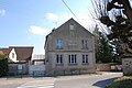
Mairie (Town Hall)


literature
- Le Patrimoine des Communes de la Seine-et-Marne . Flohic Editions, Volume 1, Paris 2001, ISBN 2-84234-100-7 , pp. 161-163.
Web links
Commons : Recloses - collection of pictures, videos and audio files