Achères-la-Forêt
| Achères-la-Forêt | ||
|---|---|---|
|
|
||
| region | Île-de-France | |
| Department | Seine-et-Marne | |
| Arrondissement | Fontainebleau | |
| Canton | Fontainebleau | |
| Community association | Pays de Fontainebleau | |
| Coordinates | 48 ° 21 ′ N , 2 ° 34 ′ E | |
| height | 73-126 m | |
| surface | 12.60 km 2 | |
| Residents | 1,125 (January 1, 2017) | |
| Population density | 89 inhabitants / km 2 | |
| Post Code | 77660 | |
| INSEE code | 77001 | |
| Website | http://www.achereslaforet.net/ | |
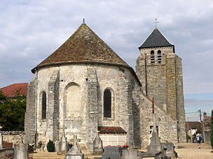
 Sainte-Fare church |
||
Achères-la-Forêt is a French commune with 1,125 inhabitants (at January 1, 2017) in the Seine-et-Marne in the region Ile-de-France . It belongs to the Arrondissement of Fontainebleau and the Canton of Fontainebleau . The inhabitants call themselves Achèrois .
geography
The place is 60 kilometers southeast of Paris. The municipality is located in the Gâtinais français Regional Nature Park .
Achères-la-Forêt is surrounded by the four neighboring communities:
| Noisy-sur-École | ||

|
||
| Le Vaudoué | La Chapelle-la-Reine | Ury |
history
Achères-la-Forêt is first documented in the 11th century. The manorial rule in the village belonged to different families throughout history.
Population development
| year | 1962 | 1968 | 1975 | 1982 | 1990 | 1999 | 2007 |
| Residents | 782 | 459 | 647 | 754 | 903 | 1040 | 1242 |
Attractions
- Sainte-Fare church, built from the 12th century ( Monument historique )
literature
- Le Patrimoine des Communes de la Seine-et-Marne . Flohic Editions, Volume 1, Paris 2001, ISBN 2-84234-100-7 , pp. 131-132.
Web links
Commons : Achères-la-Forêt - collection of images, videos and audio files
- Achères-la-Forêt at annuaire-mairie.fr (French)
