
Darvault
| Darvault | ||
|---|---|---|
|
||
| region | Île-de-France | |
| Department | Seine-et-Marne | |
| Arrondissement | Fontainebleau | |
| Canton | Nemours | |
| Community association | Pays de Nemours | |
| Coordinates | 48 ° 16 ' N , 2 ° 44' E | |
| height | 57-137 m | |
| surface | 7.83 km 2 | |
| Residents | 875 (January 1, 2017) | |
| Population density | 112 inhabitants / km 2 | |
| Post Code | 77140 | |
| INSEE code | 77156 | |
| Website | http://www.mairie-darvault.fr/ | |
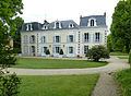
 Mairie Darvault |
||

Darvault is a French municipality with 875 inhabitants (as of January 1 2017) in the department of Seine-et-Marne in the region Ile-de-France . It belongs to the Arrondissement of Fontainebleau and the Canton of Nemours .
geography
Darvault is located in the south of the Seine-et-Marne department three kilometers east of Nemours and five kilometers south of Montcourt-Fromonville .
| Saint-Pierre-lès-Nemours | Montcourt-Fromonville | Nonville |
| Nemours |
.svg)
|
Treuzy-Levelay |
| Poligny |
Attractions
- lock
- Sacré-Cœur Church
- Lavoir (wash house)
lock

Sacré-Cœur Church ( Holy Cross )
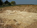
Archaeological excavations


_-_02.JPG)
literature
- Le Patrimoine des Communes de la Seine-et-Marne . Flohic Editions, Vol. 2, Paris 2001, ISBN 2-84234-100-7 , pp. 1136-1137.
Web links
Commons : Darvault - collection of images, videos and audio files
- Darvault at annuaire-mairie.fr (French)