
Remauville
| Remauville | ||
|---|---|---|
|
||
| region | Île-de-France | |
| Department | Seine-et-Marne | |
| Arrondissement | Fontainebleau | |
| Canton | Nemours | |
| Community association | Moret Seine et Loing | |
| Coordinates | 48 ° 13 ' N , 2 ° 49' E | |
| height | 114-136 m | |
| surface | 10.88 km 2 | |
| Residents | 459 (January 1, 2017) | |
| Population density | 42 inhabitants / km 2 | |
| Post Code | 77710 | |
| INSEE code | 77387 | |
 Mairie of Remauville |
||

Remauville is a French commune in the Seine-et-Marne in the region Ile-de-France . It belongs to the canton of Nemours in the Arrondissement of Fontainebleau . The residents call themselves Remauvillois or Remauvilloises.
geography
It borders on Nanteau-sur-Lunain in the north, Paley in the northeast, Lorrez-le-Bocage-Préaux in the east, Chaintreaux in the south and Poligny in the west . In addition to the main settlement, Remauville also includes the hamlets of Bouchereau and Savigny.
Population development
| year | 1962 | 1968 | 1975 | 1982 | 1990 | 1999 | 2008 | 2013 |
|---|---|---|---|---|---|---|---|---|
| Residents | 334 | 314 | 315 | 297 | 335 | 368 | 444 | 471 |
Attractions
- War memorial
- Military cemetery
- Saint-Médard Church (see also: List of Monuments historiques in Remauville )

War memorial
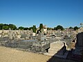
Military cemetery

Saint-Médard church

Cross at the rue du Cimetière


literature
- Le Patrimoine des Communes de la Seine-et-Marne . Flohic Editions, Volume 1, Paris 2001, ISBN 2-84234-100-7 , pp. 684-686.
Web links
Commons : Remauville - collection of pictures, videos and audio files