
Maisoncelles-en-Gâtinais
| Maisoncelles-en-Gâtinais | ||
|---|---|---|
|
||
| region | Île-de-France | |
| Department | Seine-et-Marne | |
| Arrondissement | Fontainebleau | |
| Canton | Nemours | |
| Community association | Gâtinais-Val de Loing | |
| Coordinates | 48 ° 11 ' N , 2 ° 38' E | |
| height | 101-118 m | |
| surface | 8.58 km 2 | |
| Residents | 133 (January 1, 2017) | |
| Population density | 16 inhabitants / km 2 | |
| Post Code | 77570 | |
| INSEE code | 77271 | |
 Maisoncelles-en-Gâtinais |
||

Maisoncelles-en-Gâtinais is a French commune in the Seine-et-Marne in the region Ile-de-France . It belongs to the canton of Nemours (until 2015 canton of Château-Landon ) in the arrondissement of Fontainebleau . The residents call themselves Maisoncellois or Maisoncelloises.
geography
The municipality borders on Aufferville to the west and north-west , Bouligny to the north-east, Chenou to the south-east, Mondreville to the south and Arville to the south-west .
Population development
| year | 1962 | 1968 | 1975 | 1982 | 1990 | 1999 | 2008 | 2013 |
|---|---|---|---|---|---|---|---|---|
| Residents | 143 | 134 | 111 | 90 | 107 | 112 | 136 | 128 |
Attractions
See also: List of Monuments historiques in Maisoncelles-en-Gâtinais
- Saint-Michel church, built in the 13th century, monument historique

Saint-Michel church
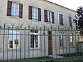
Mairie (Town Hall)


literature
- Le Patrimoine des Communes de la Seine-et-Marne . Flohic Editions, Volume 1, Paris 2001, ISBN 2-84234-100-7 , pp. 215-217.
Web links
Commons : Maisoncelles-en-Gâtinais - collection of images, videos and audio files