
Larchant
| Larchant | ||
|---|---|---|
|
||
| region | Île-de-France | |
| Department | Seine-et-Marne | |
| Arrondissement | Fontainebleau | |
| Canton | Nemours | |
| Community association | Pays de Nemours | |
| Coordinates | 48 ° 17 ′ N , 2 ° 36 ′ E | |
| height | 62-141 m | |
| surface | 29.24 km 2 | |
| Residents | 696 (January 1, 2017) | |
| Population density | 24 inhabitants / km 2 | |
| Post Code | 77760 | |
| INSEE code | 77244 | |
 Mairie Larchant |
||

Larchant is a French municipality with 696 inhabitants (as of January 1 2017) in the department of Seine-et-Marne in the region Ile-de-France . It belongs to the Arrondissement of Fontainebleau and the Canton of Nemours .
location
The municipality is located in the Gâtinais français Regional Nature Park .
| La Chapelle-la-Reine | Villiers-sous-Grez , Grez-sur-Loing | |
| Amponville |
.svg)
|
Saint-Pierre-lès-Nemours |
| Guercheville | Chevrainvilliers |
Attractions
See also: List of Monuments historiques in Larchant
- Saint-Mathurin basilica
- Farm with a pigeon tower
- Grotto à la peinture , cave paintings

Saint-Mathurin basilica
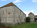
"Ferme du Chapitre"


literature
- Le Patrimoine des Communes de la Seine-et-Marne . Flohic Editions, Volume 1, Paris 2001, ISBN 2-84234-100-7 , pp. 153-157.
Web links
Commons : Larchant - collection of images, videos and audio files