
Bougligny
| Bougligny | ||
|---|---|---|
|
||
| region | Île-de-France | |
| Department | Seine-et-Marne | |
| Arrondissement | Fontainebleau | |
| Canton | Nemours | |
| Community association | Gâtinais-Val de Loing | |
| Coordinates | 48 ° 12 ' N , 2 ° 39' E | |
| height | 98-121 m | |
| surface | 16.31 km 2 | |
| Residents | 725 (January 1, 2017) | |
| Population density | 44 inhabitants / km 2 | |
| Post Code | 77570 | |
| INSEE code | 77045 | |
| Website | http://www.bougligny.fr/ | |
 Mairie Bougligny |
||

Bougligny is a commune with 725 inhabitants (as of January 1 2017) in the Seine-et-Marne in the region Ile-de-France . It belongs to the Arrondissement of Fontainebleau and the Canton of Nemours .
geography
Bougligny is about ten kilometers southwest of Nemours and 16 kilometers east of Puiseaux .
| Aufferville | Faÿ-lès-Nemours | Bagneaux-sur-Loing |
| Maisoncelles-en-Gâtinais |
.svg)
|
La Madeleine-sur-Loing |
| Chenou | Château-Landon | Souppes-sur-Loing |
Bougligny consists of the following localities:
- Foljuif
- Le Tillet
- La Cuillère
- Quenonville
- Corbeval
- Thiersanville
There are no bodies of water in the municipality .
history
Bougligny was first mentioned in a document in the 12th century. From 1285 it was owned by the crown.

Bougligny
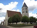
Nativité-de-la-Sainte-Vierge Church ( Nativity of the Virgin Mary )

.JPG)
.jpg)
Attractions
See: List of Monuments historiques in Bougligny
literature
- Le Patrimoine des Communes de la Seine-et-Marne . Flohic Editions, Volume 1, Paris 2001, ISBN 2-84234-100-7 , pp. 188-189.
Web links
Commons : Bougligny - collection of images, videos and audio files
- Bougligny at annuaire-mairie.fr (French)