
Strategic embankment
Coordinates: 51 ° 4 ′ 44 " N , 6 ° 42 ′ 29.9" E

The Strategische Bahndamm (also Ruhr-Moselle relief line ) is a railway line that began in 1904 but was not completed between the Ruhr area and the south-western border of Germany . The eponymous part of this railway line is a railway embankment between Neuss and Rommerskirchen , which was built for the northern section of the line.
history
At the beginning of the 20th century, the railroad was increasingly included in strategic considerations of the military, especially for the rapid deployment of German troops against France. Under the influence of the Chief of the General Staff of the Imperial Army, Alfred von Schlieffen , a whole series of new railway lines were planned as strategic routes and in some cases also implemented. The strategic embankment is one of them.
course
The planning saw u. a. proposed that a multi-track main line should be built from Wesel , bypassing Crefeld and Neuss via Rommerskirchen , Niederaussem , Horrem , Liblar and Rheinbach to Rech im Ahrtal, to relieve the Rhine Valley lines and bypassing the railway bottlenecks in Cologne and Düsseldorf . The trains should then be able to reach Saarland and Lorraine via the Ahr and Eifel railway. In 1915 it was also decided to run the "Ruhr-Moselle relief line" in a southerly direction over a section Ringen - Bad Bodendorf and further over the Ahr Valley Railway directly to the Rhine Valley routes and to connect them to the Remagen railway junction . In addition, a multi-track main line was planned , starting with a branch north and in Rheinbach, via Münstereifel and Schmidtheim to Kronenburg and Stadtkyll (with a track triangle at these places) to the Vennquerbahn ( Jünkerath - Malmedy route ).
implementation
Construction began in 1904. After the First World War , France prevented its completion in 1924. Over a length of 13 km between Holzheim (now part of Neuss) and Rommerskirchen, a railway embankment with bridge structures for crossing traffic was built. From Rommerskirchen via Niederaussem to Liblar , the route was already passable by trains, as the Bergheimer Kreisbahn had been running here for several years .
Sections of the route (as embankment or trough) in the Rheinbach / Meckenheim area as well as road overpasses and railway tunnels near Ahrweiler were also completed. The pillars were erected for the viaduct over the Adenbachtal near Ahrweiler. The arches were already shuttered for concreting when construction work stopped. Rails had not yet been laid. Individual station buildings had been erected, for example in Altendorf near Meckenheim , which was built around 1920, served as a residential building and was demolished in 1968/69 for the construction of the federal motorway 61 .
Sections
Section Neuss - Rommerskirchen
The part of the strategic embankment between Neuss and Rommerskirchen is now a footpath, a bridle path and a ground monument . Roads and country lanes were built over with bridges to avoid crossings. Like the railway embankment, these structures have been largely unused for around 80 years. At its northern end is the island of Hombroich .

Course between Neuss and Rommerskirchen
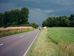
In the Rhine district of Neuss between Hülchrath (left) and Neukirchen (right): The L 142 cuts the embankment in a lowered direction towards the northeast

Road bridge

Crossing under Münchrath
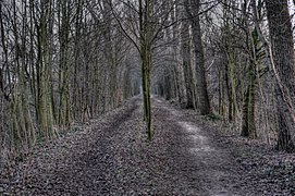
Near Münchrath,
looking south


Rommerskirchen - Mödrath section
This section was built as part of two different Bergheimer Kreisbahn railway projects , the Elsdorf – Mödrath railway line opened in 1896, and the Bedburg – Rheidt railway line opened a year later , which was extended to Rommerskirchen in 1904. The Niederaussem – Martinswerk connection as part of the strategic line was put into operation in 1926.
Two parts of these rail projects are still in use today. The route between Rommerskirchen and Niederaussem is only used by freight trains and is mainly used to connect the power station in Niederaussem. The only section that is used by passenger trains is between Bergheim Martinswerk (former junction, now route change) and Horrem station . This section is now included in the Erftbahn .
The line between Niederaussem and Martinswerk was in the way of the Bergheim opencast mine and was closed in 1971, and the tracks south of Horrem were also closed in 1978.
Section Mödrath - Liblar
Section Liblar - Rech

The route between Liblar and Ringen (Grafschaft) ( Lage ) was largely included in the motorway when the A 61 was built . In rings nor ,, Bahnhofstrasse "remember that used as a sports field area of the railway tracks, rows of poplars and underpasses in the high embankments of the construction project. In Ahrweiler a viaduct and five were railway tunnel required to descend about 100 meters to the Ahrtalbahn to deal with.
The image collection below shows the tunnel portals and route sections.
North of Ahrweiler , the route was to cross the Adenbachtal with a viaduct. The pillars were erected and the arches covered, but not completed after the French forbade further construction. In the adjoining Silberberg tunnel, a memorial was set up at the east portal to commemorate the fate of the residents of Ahrweiler who sought protection here during the bombing nights of World War II . Between 1960 and 1972, during the "Cold War" , with the involvement of the Kuxberg Tunnel and Trotzenberg Tunnel, the alternative seat of the federal constitutional organs in the event of a crisis and defense was built to maintain their functionality (AdVB) (government bunker ) near Ahrweiler. The bunker was abandoned in 1997 and largely gutted by 2006. Today the government bunker documentation center is housed there. The way from the parking lot to the entrance of the documentation center runs along the old railway line from the blasted west entrance of the Silberberg tunnel to the former east portal of the Kuxberg tunnel, which is now the entrance to the documentation center. In the photo it is covered by trees. The old portals of the Kuxberg tunnel and the Trotzenberg tunnel gave way to the security systems for the government bunker.
Further south the route led into the Sonderberg tunnel. Today it is used as a warehouse. A few meters from the north portal, old towering wall arches, not visible in the photo, secure the route. The picture above shows the south portal. The embankment was removed, and the remains of the wall from the former underpass enclose a small vineyard. At Rech, the route led through the Herrenberg tunnel and ended at the branch of the Ahr Valley Railway. The tunnel portal of the Herrenberg tunnel was blown up, the tunnel exit to the northeast has been buried. The excess width of the embankment at the junction is clearly visible from the underpass of the B 267, as is the left supporting wall at the former access. In the small photo, the red line marks the course of the railroad tracks. At their lowest point they flowed into the mountain.

Ringen - Bad Bodendorf section
With the southeast exit of Ringen station, the strategic embankment branches off into the double-track route of the section to Rech and the single-track route to Bad-Bodendorf. The track of the section Ringen - Bad Bodendorf was to be laid first via Bengen to Nierendorf, then in an arc around Birresdorf and in an S-shaped design by Grafschaft again past Nierendorf and not far from Kirchdaun via Gimmigen to Bad Bodendorf . There the confluence with the Ahr Valley Railway was planned. The total length of the route should be 15 km.
Intermediate stations were also planned in Nierendorf, Kirchdaun and Gimmigen . The route down into the Ahr valley was a major challenge, as there was a difference in altitude of around 130 meters to overcome.
In 1918 the construction of the section from Ringen to the planned Nierendorf station between Nierendorf and Leimersdorf began . By autumn 1926, the sub-section of the Ringen - Nierendorf section had been completed. Then the construction of the route stopped. Disputes about the route, the expected high costs due to the necessary bridges and tunnels and, last but not least, the declining strategic importance of the railway led to the fact that the activities were discontinued. The route to the Nierendorf train station is now partially built over by the federal motorway 61 , but large parts of it are still clearly visible. The site of the planned Nierendorf station is now used as a sports field.
See also
Web links
- The strategic embankment at OpenStreetMap.org
- The strategic embankment at Wisoveg ...
- The strategic railway in Grafschaft and in the Ahr Valley
- Pictures of the still existing tunnel portals
- On the history of Nierendorf
- The strategic railway line (Ahrweiler)
- Silberberg Tunnel Memorial (Ahrweiler)