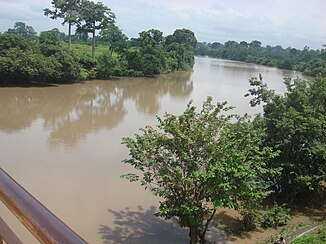
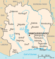
Bandama (river)
| Bandama | ||
|
Bandama river system |
||
| Data | ||
| location |
|
|
| River system | Bandama | |
| source | near Korhogo | |
| Source height | about 500 m | |
| muzzle |
Gulf of Guinea Coordinates: 5 ° 8 ′ 13 ″ N , 5 ° 0 ′ 30 ″ W 5 ° 8 ′ 13 ″ N , 5 ° 0 ′ 30 ″ W |
|
| Mouth height | 0 m | |
| Height difference | about 500 m | |
| Bottom slope | about 0.48 ‰ | |
| length | 1050 km | |
| Catchment area | 99,700 km² | |
| Discharge at the Tiassalé gauge (1426380) A Eo : 95,500 km² Location: 110 km above the mouth |
NNQ MNQ 1954–1991 MQ 1954–1991 Mq 1954–1991 MHQ 1954–1991 HHQ (max. Month Ø) |
0 l / s 58 m³ / s 263 m³ / s 2.8 l / (s km²) 842 m³ / s 2450 m³ / s |
| Left tributaries | N'Zi | |
| Right tributaries | Solomougou, Bou , Badenou, Marahoué | |
| Reservoirs flowed through | Kossoustausee | |
The Bandama is a 1050 kilometer long river in central Ivory Coast in West Africa . It is the river with the largest catchment area in the country.
course
The river runs in the middle of the Ivory Coast and divides the country in half from north to south.
The naming is comparable to that of the Volta , in which the main river arises only about halfway through the flow stretch from the White Bandama and the Red Bandama ( Marahoué ). Its most important tributary, the N'Zi , also flows very late.
White bandama
The White Bandama (or Bandama Blanc in French ) is produced in the 500 m high dry savannah in the north of the country. It is considered to be the actual headwaters of the Bandama. the boundaries of its catchment area extend to the border with Mali . It initially flows over 100 km to the east. Then it bends to the south, where after a further 100 km it takes up the tributary Bou , which flows out to the right . A little later it flows through the Kossoustausee , which was formed in 1973 by the construction of the Kossou power station near Kossou . shortly after leaving the reservoir, it unites with the Red Bandama.
Red bandama
The Red Bandama (Marahoué, French Bandama Rouge ) has a length of 550 km and rises as Kahoua near Boundiali . In the city of Mankono, he changes his name to Marahoué. Like the White Bandama, it flows from north to south. It joins the White Bandama 30 km northwest of Yamoussoukro .
Bandama
The river, which flows further south, is in turn dammed by the Taabo power plant , before it is finally fed 100 km before its mouth by the tributaries of the N'Zi . Finally, it flows into the Tagba lagoon on the Gulf of Guinea .
Hydrometry
The flow rate of the river in Tiassalé was measured in m³ / s for over 90% of the catchment area

Catchment area
The catchment area of the Bandama has a size of about 99,700 km². This corresponds to just over 30% of the country's area.
| Rivers | Area [km²] |
|---|---|
| Badenou | 2,400 |
| Solomougou | 1,600 |
| Bou | 5,100 |
| Marahoué | 21,600 |
| N'Zi | 35,500 |
| Bandama overall | 99,700 |
Hydropower plants
Individual evidence
- ↑ a b c d JICA publication
- ↑ a b Tiassale gauge
literature
- Wolf Tieltze: Lexicon of Geography . Braunschweig: Westermann, 1968. Vol. 1, p. 336.
Web links
- country-study at mongabay.com (English)


