Bauerberg (Zemitz)
| Bauerberg | ||
|---|---|---|
|
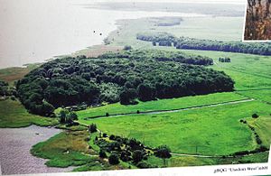
Aerial view of the Bauerberg |
||
| height | 23 m above sea level NHN | |
| location | Mecklenburg-Western Pomerania , Germany | |
| Coordinates | 53 ° 58 '58 " N , 13 ° 49' 51" E | |
|
|
||
| Type | Terminal moraine | |
The Bauerberg is a 23-meter-high elevation at its highest point in the municipality of Zemitz in the Vorpommern-Greifswald district in the northeast of Mecklenburg-Western Pomerania .
location
The elevation is located on the western bank of the Peene River between Lassan and Wolgast south of the Brebowbach . It can be reached via the street Zum Bauerberg , which leads in the Zemitz district of Alt Bauer in an easterly direction along the church of St. Nikolai zu Bauer in the direction of Peenestrom to the residential area of the same name . The elevation belongs to the edge of the ice Velgaster Staffel , which runs in an arc from Velgast via Stralsund and Greifswald to Wolgast and to Usedom .
Origin and shape
During the Vistula Ice Age , there was an increased accumulation of snow in Scandinavia . These pushed a glacier several times in the direction of the elevation. This resulted in a compression of the terminal moraine by the ice sheet and, as a consequence, the formation of an isolated terminal moraine dome.
In the 21st century, this hilltop is covered with mixed forest. Towards the Peene River there is a cliff that formed during the Littorina Transgression about 7000 BC. BC originated. At that time the water reached up to the foot of the slope of the Bauerberg and led to material erosion during a storm. This can still be recognized in the 21st century by the comparatively unusual steepness of the slope. In addition, there are still large debris from this time on the chute . After the water receded, the chute fell partially dry and the adjacent lowlands became boggy.
Historical postcards from the 1920s show a restaurant and a house on the Bauerberg.
Mountain snake in the farmer mountains
The Bauerberg is the scene of a Greifswald legend , which the folklorist Alfred Haas brought together in a collection in 1925. According to legend, there was a large snake in the mountain. If it is sighted, an accident will happen nearby. The one who discovers the reptile is most affected. The last sighting took place on June 13, 1817 by a peasant woman. The following day, a fire broke out in Bauer parish that destroyed 32 houses. The farmer's wife was killed in this fire.
literature
- Alfred Haas : Greifswald legends. Abel, Greifswald 1925.
Web links
Individual evidence
- Information board : Bauerberg in Alt-Bauer, inspection in July 2015
- ↑ Jodocus Donatus Hubertus Temme: The folk tales of Pomerania and Rügen . Nicolai, 1840, p. 270.

