Bayana
| Bayana बयाना |
||
|---|---|---|
|
|
||
| State : |
|
|
| State : | Rajasthan | |
| District : | Bharatpur | |
| Sub-district : | Bayana | |
| Location : | 26 ° 54 ' N , 77 ° 18' E | |
| Height : | 204 m | |
| Area : | 5.68 km² | |
| Residents : | 38,502 (2011) | |
| Population density : | 6779 inhabitants / km² | |
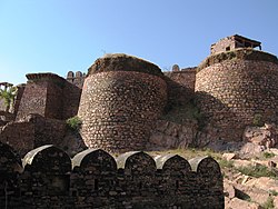
| Bayana - fort | ||
Bayana (Hindi: बयाना) is a north Indian city with about 40,000 inhabitants in the Bharatpur district in eastern Rajasthan .
location
Bayana is located about 45 km (driving distance) southwest of Bharatpur or about 82 km southwest of Mathura ( Uttar Pradesh ) on the eastern edge of the Aravalli Mountains at an altitude of about 205 m above sea level. d. M .; the megacity Jaipur is located 180 km to the west. The climate is rather dry and warm; Rain falls almost exclusively during the summer monsoon season .
population
Official population statistics have only been kept and published since 1991.
| year | 1991 | 2001 | 2011 |
| Residents | 26,529 | 33,716 | 38.502 |
The Hindi and Urdu- speaking population consists of about 96% Hindus , 2.8% Muslims and just under 1% Jains ; numerically small minorities are Christians , Sikhs , Buddhists and others. As is customary in censuses in northern India, the male population is about 12% higher than the female.
economy
Traditionally, the basis of life is agriculture in the surrounding villages; Craftsmen, traders and smaller service companies have settled in the city. Tourism only plays a subordinate role.
history
Bayana (formerly Shripatha or Shriprashtha ; later also Bijayagadh ) is an ancient city: Abu 'l-Fazl reports that it was the capital of a large area ruled by the Jadon Rajputs , which also included Agra . As part of the Islamic campaigns of Mahmud of Ghaznis in the northwest of the Indian subcontinent, the city was conquered at the beginning of the 11th century. Later it came under the rule of the Sultanate of Delhi, founded in 1206 . During the Mughal rule , it belonged to the province of Agra. In the 18th century Bayana came briefly under the rule of the Marathas and then the Jat - princely state of Bharatpur . After the Battle of Deeg (1804), the British took control of the princely state, which was incorporated into the state of Rajasthan in 1949 and dissolved in 1956.
Attractions
- A pillar ( Bhim Lat ) with an inscription of the minor king Vishnuvardhana , who was dependent on the Gupta ruler Samudragupta (r. 335-375 / 80) , dates from the year 372/3 AD .
- A medieval Hindu temple ( Usha Mandir ) may date from the middle of the 10th century.
- The Bijayagarh Fort , which was still medieval in its origins, but later repeatedly renovated and strengthened, rises on a hill near the city. The Mughal Mogul Babur counted it among the largest fortifications of his empire.
- The Nohara Masjid may have been built during the reign of Qutb ud-Din Aibak (ruled 1206-1210) over the Sultanate of Delhi .
- A mausoleum commemorates Abubakr Kandahari ; he was a comrade in the conquest of the region by Qutb ud-Din Aibak at the beginning of the 13th century and is today revered as holy by many.
- An unfinished minaret bears the name Lodi Minar and commemorates the sovereignty of the Lodi dynasty, who resided in Delhi around 1520 .
Web links
- Bayana, Bhim Lat - Photo + Info (JatlandWiki, English)
- Bayana, Usha Mandir - Photo + Info ( ASI , English)
- Bayana - Photo + Info (English)
- Bayana, Fort - Photo + Info (ASI, English)
- Bayana, Fort and Bhim Lat - photo + brief information (English)
- Bayana, Lodi-Minar - Photos + Info (ASI, English)

