Bellonne (river)
| Bellonne | ||
|
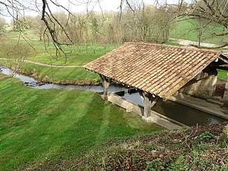
The river by the Saint-Adjutory wash-house |
||
| Data | ||
| Water code | FR : R --- 2610 | |
| location | France , Nouvelle-Aquitaine region | |
| River system | Charente | |
| Drain over | Touvre → Charente → Atlantic Ocean | |
| source | in the municipality of Mazerolles 45 ° 44 ′ 31 ″ N , 0 ° 31 ′ 39 ″ E |
|
| Source height | approx. 292 m | |
| as part of a karst spring | in the municipality of Touvre in the Touvre coordinates: 45 ° 39 ′ 48 ″ N , 0 ° 15 ′ 16 ″ E 45 ° 39 ′ 48 ″ N , 0 ° 15 ′ 16 ″ E |
|
| Mouth height | approx. 63 m | |
| Height difference | approx. 229 m | |
| Bottom slope | approx. 7.2 ‰ | |
| length | approx. 32 km | |
|
The karst springs of the Touvre |
||
The Bellonne is a river in France , in the Charente department in the Nouvelle-Aquitaine region .
course
It rises in the municipality of Mazerolles and initially drains in a north-westerly direction. At Taponnat-Fleurignac it crosses the motorway- like route nationale 141 and the parallel railway line Limoges-Bénédictins-Angoulême . About one kilometer further it reaches the karst area of La Rochefoucauld , where it disappears completely underground ( infiltration point: 45 ° 46 ′ 52 ″ N , 0 ° 23 ′ 37 ″ E ). The further course of the river to the original confluence with the Tardoire can only be seen today as a dry valley . The seeping water masses of the Bellonne move south-west, reappear at Touvre , near Angoulême , and form the Touvre River together with other karst springs . The total length of the Bellonne is around 32 kilometers.
Places on the river
(Order in flow direction)
- Les Chevaleries , Mazerolles municipality
- Condadeuil , Mazerolles parish
- Saint-Adjutory
- Fleurignac , municipality of Taponnat-Fleurignac
- Taponnat , municipality of Taponnat-Fleurignac

