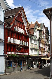
Appenzell (District)
| Appenzell | |
|---|---|
| State : |
|
| Canton : |
|
| BFS no. : | 3101 |
| Postal code : | 9050 |
| UN / LOCODE : | CH APP |
| Coordinates : | 749 492 / 244 381 |
| Height : | 780 m above sea level M. |
| Height range : | 740–1341 m above sea level M. |
| Area : | 16.88 km² |
| Residents: | 5795 (December 31, 2018) |
| Population density : | 343 inhabitants per km² |
|
Proportion of foreigners : (residents without citizenship ) |
18.3% (December 31, 2018) |
| Website: | www.appenzell.org |
| Location of the municipality | |
Appenzell is a district and the capital of the Swiss canton of Appenzell Innerrhoden .
Settlement structure
Part of the village of Appenzell and the localities of Rinkenbach, Kau and Meistersrüte with the hamlet of Brenden are in the district .
Localities
Appenzell
The core of the village of Appenzell belongs to the Appenzell district.
Brenden
The at around 1000 m above sea level. M. located hamlet Brenden is between Appenzell and Gais and belongs to Meistersrüte. This settlement can be reached from the assembly point via an approximately 2.5 km long corridor road (corporation Oberlehn-Weesen) .
history
The Appenzell district was created in 1872 from the Rhode Lehn and parts of the Rhode Rinkenbach .
Attractions
In Mettlen, a covered wooden bridge leads over the Sitter. This was probably built around 1766 by a member of the master builder family Grubenmann.
The castle hill with the Clanx ruins is located north of Appenzell . The castle was built in 1219 under Abbot Ulrich VI. built by St. Gallen. Their destruction by the rebellious peasants triggered the Appenzell Wars of Independence in 1401 . The castle, which was destroyed in 1402, was excavated in 1949.
Web links
- Official website of the Appenzell district
- Achilles Weishaupt: Appenzell (district). In: Historical Lexicon of Switzerland .
- Hermann Bischofberger: Lehn. In: Historical Lexicon of Switzerland .
- Castle world: Castle Clanx
Individual evidence
- ↑ Permanent and non-permanent resident population by year, canton, district, municipality, population type and gender (permanent resident population). In: bfs. admin.ch . Federal Statistical Office (FSO), August 31, 2019, accessed on December 22, 2019 .
- ↑ Our Inner Rhodes in numbers. (PDF; 1.61 MB) Cantonal Administration of Appenzell Innerrhoden, p. 2 , accessed on December 22, 2019 (population data according to the residents' registration of the canton of Appenzell Innerrhoden).
- ↑ Fischer, 1984, 375, 376.
- ↑ Fischer, 1984, 480-483.


