
Oberegg AI
| AI is the abbreviation for the canton of Appenzell Innerrhoden in Switzerland and is used to avoid confusion with other entries of the name Oberegg . |
| Oberegg | |
|---|---|
 |
|
| State : |
|
| Canton : |
|
| BFS no. : | 3111 |
| Postal code : | 9413 |
| Coordinates : | 759 562 / 254539 |
| Height : | 870 m above sea level M. |
| Height range : | 540–1135 m above sea level M. |
| Area : | 14.61 km² |
| Residents: | 1916 (December 31, 2018) |
| Population density : | 131 inhabitants per km² |
|
Proportion of foreigners : (residents without citizenship ) |
8.4% (December 31, 2018) |
| Website: | www.oberegg.ch |
 Oberegg seen from the west |
|
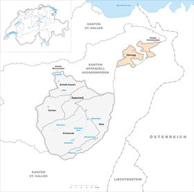
| Location of the municipality | |
  |
|
Oberegg is a district in the eastern Swiss canton of Appenzell Innerrhoden . The Oberegg district also forms the outer part of the country (all other Innerrhod districts together form the inner part of the country ) and as such maintains its own district court .
geography
Oberegg forms the southeastern part of the Appenzeller Vorderland. Of the 14.7 km 2 of the district area, 51.8% are meadows and fields, 42.5% are forested, 5.5% are built up (buildings or roads) and 0.1% are unproductive land.
The district has some peculiarities. Although it belongs to the canton of Appenzell Innerrhoden - it is completely enclosed by the cantons of Appenzell Ausserrhoden and St. Gallen and thus forms an exclave . In addition, the district itself is divided into two districts, which are not connected to each other, but are separated by part of the municipality of Reute , which belongs to Ausserrhoden. The St. Ottilia Grimmenstein Monastery , which is located in Walzenhausen Platz, also belongs to the district area. The Catholic monastery was added to the Oberegg district in the course of the cantonal division, although it is located in Walzenhausen outside of Rhodes .
The upper part of the district (also called “upper corridor”) consists of the village, St. Anton and Kapf . The lower part (also called "lower corridor") consists of the hamlets of Büriswilen, Eschenmoos and Sulzbach .
history


A discovery of Roman coins near the hamlet of Heilbronnen suggests an early inspection of the district area. The actual settlement by the Alemanni did not take place until the transition from the 12th to the 13th century, according to documentary evidence. The large number of clearing names and farm names after wild animals (Bernsboden, Bensol, Falchenstein or Uelenhorst) signify a second epoch of colonization. Only the hamlet of Büriswilen has a name from the Carolingian era. The name Oberegg appears for the first time in a letter from 1470 as a hamlet name.
The settlers came from the Rhine Valley (from Bernang , Marbach and Altstätten ) or from the Appenzeller Mittelland. They were subjects of the abbot of St. Gallen, to whom taxes were to be paid. Next to them were the secular lords of Rosenberg-Berneck and the Meier of Altstätten. The latter built Hoch-Altstätten Castle in what is now the Oberegg district .
A connection to the Appenzell freedom movement seems to have taken place only gradually. A document dated August 10, 1404 proves that the Appenzeller and Obereggern agreed on the inclusion in land law. Around the middle of the 15th century, the areas of the eastern Appenzeller Vorderland merged under the name "Nachpurschaft am Hersberg".
When the land was divided up during the Reformation in 1597, when the land of Appenzell was split into a Catholic Inner Rhodes and a Protestant Outer Rhodes, Oberegg became an exclave . In keeping with the old belief, the Oberegger Innerrhoden were struck, although they were surrounded by Protestant Rhodes . The district border is still often zigzagging today, because depending on the religious affiliation of the farmers it had to be decided to which Rhode their farm should belong.
During the Helvetic era , Oberegg and Hirschberg were added to the Wald district of the Säntis canton , while the hamlets of Kapf and Boden became part of the Upper Rhine Valley. The majority of the Obereggers were against the reorganization. This went so far that, under the leadership of Johann Kolb, arms were raised against the taking of the oath on the new constitution. On September 4, 1798, however, they were overpowered by Helvetic troops from the Herisau district near Oberholzern.
During the period of mediation , the disputes over the demarcation of the two half-cantons Inner and Outer Rhodes revived. Despite a court of arbitration introduced by the Diet , the definitive boundaries could only be drawn after the establishment of the new federal state in 1848.
The Oberegg district in its current form was created due to a new cantonal constitution in 1872 from the merger of the half-testes Hirschberg and Oberegg .
population
| year | 1850 | 1900 | 1910 | 1950 | 2000 | 2010 |
| Residents | 2141 | 2652 | 2862 | 2197 | 1796 | 1892 |
Attractions
- The parish church Maria zum Schnee
- Mess chapels and wayside crosses
- Feudal buildings: Castle ruins Hochaltstätten, Burgstelle Burg
- Farmhouses
tourism
There are many hiking trails and mountain bike trails. There is a ski lift from the village to St. Anton . There is a cross-country ski run around the Bensol area.

literature
- Rainald Fischer: The art monuments of the canton of Appenzell Innerrhoden. The Inner Land: The Oberegg District (= The Art Monuments of Switzerland. Volume 74). Birkhäuser AG, Basel 1984, ISBN 3-7643-1629-2 , pp. 502-521.
- Karl Bischofberger: The borders between the old half-testicles Oberegg and Hirschberg. In: Innerrhoder Geschichtsfreund 28, 1984, pp. 68-72.
- Ivo Bischofberger: Oberegg. In: Historical Lexicon of Switzerland .
- David Hänggi-Aragai: Oberegger history: The outer part of the country of Appenzell Innerrhoden (= Innerrhoder Schriften. Volume 18. ). Appenzell 2018.
- Max Sonderegger: Oberegg during the 2nd World War. Oberegg 2001.
Web links
Individual evidence
- ↑ Permanent and non-permanent resident population by year, canton, district, municipality, population type and gender (permanent resident population). In: bfs. admin.ch . Federal Statistical Office (FSO), August 31, 2019, accessed on December 22, 2019 .
- ↑ Our Inner Rhodes in numbers. (PDF; 1.61 MB) Cantonal Administration of Appenzell Innerrhoden, p. 2 , accessed on December 22, 2019 (population data according to the residents' registration of the canton of Appenzell Innerrhoden).
- ↑ Federal Statistical Office, as of 2011
- ^ Fischer, 1984, 505.
- ↑ Fischer, 1984, 514-516.
- ↑ Fischer, 1984, 514-516.
- ^ Fischer, 1984, 519.
Appenzell | Gonten | Oberegg | Hat | Schlatt-Haslen | Schwende
Former Rhodes or Halbrhoden: Hirschberg | Rinkenbach | Stechlenegg
Canton of Appenzell Innerrhoden | Districts of Switzerland | Districts of the canton of Appenzell Innerrhoden