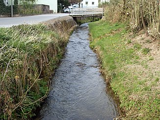
Biddersbach
| Biddersbach | ||
|
Bach in Wiesenbach |
||
| Data | ||
| Water code | DE : 238988 | |
| location |
Little Odenwald
|
|
| River system | Rhine | |
| Drain over | Elsenz → Neckar → Rhine → North Sea | |
| source | east of Neckargemünd- Mückenloch in the administrative forest that begins at 49 ° 23 '4 " N , 8 ° 52' 36" E |
|
| Source height | approx. 260 m above sea level NN | |
| muzzle | north of Bammental from the right into the lower Elsenz Coordinates: 49 ° 21 ′ 42 " N , 8 ° 47 ′ 20" E 49 ° 21 ′ 42 " N , 8 ° 47 ′ 20" E |
|
| Mouth height | approx. 125 m above sea level NN | |
| Height difference | approx. 135 m | |
| Bottom slope | approx. 14 ‰ | |
| length | 9.8 km | |
| Catchment area | approx. 17.52 km² | |
The Biddersbach is a small brook between Kraichgau and Kleiner Odenwald . It flows through the village of Wiesenbach and flows into the Elsenz from the right just outside Bammental . State road 532 follows the stream for most of its course.
course
The 9.8 km long stream has its source just as far northwest of Waldwimmersbach as it is east-southeast of Mückenloch on the municipal boundary between Lobbach and Neckargemünd , which runs along the edge of the administrative forest. Initially it flows southwards and after a few hundred meters it crosses under the district road 4101 at the crossover into the open corridor. Past the newer industrial area of Waldwimmersbach on the left slope, it now moves in a south-southwest direction and past the Biedersbacherhof (?) To get on the site of the Heidelberg-Lobenhof golf club, where the Haselwiesengraben feeds it from the north, to run a little more south-west.
To the west of Lobenfeld , the brook turns to the north-west, from the right picks up the field slope ditch that was left a little earlier and the Sauloch ditch, before following a roughly westerly direction. Before entering Wiesenbach, the Wurzbach flows into it from the north and the river ditch flows into the village from the south about four hundred further west. Further down in the village, its longest and most catchment-rich tributary runs towards Totenkopfgraben in the valley of the former Maurer Neckarschlinge, then the Biddersbach crosses under federal highway 45 at the western end of the village . It finally flows northeast of Bammental into the Elsenz, where it enters between the Holmut on the right and the Bammerstberg on the left into its hillside forested lower course narrow valley in the course of the receding part of the old Neckar loop.
Tributaries
From the origin to the mouth.
- Buchwaldgraben , from the left and east a little after the origin in the forest district Buchwald
- Haselwiesengraben , from the right and north to the Biddersbacher Hof on the golf course area
- Waldwiesenbach , from the right and north at the Klingentaler Hof
- Shaft drive ditch, from the left and south a little after the previous one at the southernmost point of the course
- → Exit of the secondary channel Feldabhanggraben, to the right immediately after the previous one
- Kopfbrunnengraben, from the right and north into the field slope ditch in front of the park area around Langenzell Castle
- ← Return of the secondary channel Feldabhanggraben , from the right from the castle grounds
- Saulochgraben , from the right and north-west near Langenzell
- Wurzbach , from the right and north in front of the sports area on the eastern edge of Wiesenbach
- River ditch , from the left and south in the eastern Wiesenbach
- Totenkopfgraben , from the right and northeast in the western Wiesenbach
