
Biegwald
The Biegwald is an 18.4 hectare unmanaged forest park in the city of Frankfurt am Main . It is located in the Bockenheim and Rödelheim districts west of the city center . As part of the Frankfurt green belt, the forest is a designated landscape protection area .
history
.jpg)
The Biegwald was named after the village of Biegen , which perished in 1295, and the Lords of Biegen , mentioned in 1151 , who had owned shares in Frauenstein Castle since 1221 and probably died out in the late 14th century. Like the Niedwald to the southwest, it is a remnant part of an old alluvial forest with hornbeams ( Carpinus betulus ), oaks ( Quercus ) and elms ( Ulmus ) as well as a diverse native herb flora. This vegetation is typical of the vegetation that used to cover large areas of the often flooded valley of the Main and Nidda rivers .
.jpg)
The forest is located in the historical border area between the former place Bockenheim (which belonged to the Bornheimerberg office of the County of Hanau since the late Middle Ages and to the Electorate of Hesse from the 19th century ) and the place Rödelheim (from the 15th to the early 19th century of the County of Solms -Rödelheim belonging). Two boundary stones from the late 18th century on the northern edge of the Biegwald forest attest to this. A section of the old Antsanvia road , a historic trade route from Mainz to Eisenach , leads through the forest in a southwest-northeast direction with the Biegweg . In 1897 the Biegwald became the property of the city of Frankfurt through purchase.
Until the Second World War , there was a forester's house in the Biegwald, whose tavern was a popular excursion destination for Bockenheimer and Rödelheimer citizens. According to the municipal documents at the Institute for Urban History , during the air raids on Frankfurt am Main in the night of April 24th to 25th 1942, allied bombers dropped aerial bombs , which hit the Biegwald forester's lodge, which housed forced laborers from Bockenheimer VDO AG during the war were. Numerous people died in the process. The property was destroyed.
Location and infrastructure
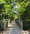
Today the Biegwald is bordered in the south by the S-Bahn line of the Homburg Railway and in the east by Ludwig-Landmann-Straße . The wooded area is connected to the settlement area of the district by the Rödelheimer railway and pedestrian bridge over the Nidda; a footbridge over the Rödelheimer Nidda tributary Mühlgraben leads to the north-west bordering Solmspark .
In and on the Biegwald there are children's playgrounds for all age groups as well as the Biegwald playground and football field at the Hessenkolleg Frankfurt on Biegweg and at the neighboring post office to the northeast near Rebstöcker Weg . On the southwestern edge of the Biegwald forest on Rebstöcker Weg, there is a forest restaurant called Haus Biegwald and next to it a sports club for protection and working dogs. The traditional amateur sports club TSG Vorwärts Frankfurt also maintains a large, partially developed sports area there.

Postal settlement on the Biegwald

Access from the Biegweg
Bridge over the Mühlgraben in Solmspark

Rödelheim Bockenheim boundary stone of the 18th century on the western edge of the Biegwald, view northeast

The 18th century boundary stone Rödelheim Bockenheim on the western edge, north view

The 18th century boundary stone Rödelheim Bockenheim on the western edge, view from the west

The 18th century boundary stone Rödelheim Bockenheim on the western edge, view southeast


literature
- Emil Hartmann: Alt-Rödelheim - A home book. Englert & Schlosser, 1921
- Helmut Nordmeyer: ramparts - green spaces. Institute for City History, Frankfurt am Main, 2003. Publication for the exhibition from June 3 to September 28, 2003 in the Institute for City History, in the dormitory of the Carmelite Monastery.
- Paul Schubert: The picturesque Rödelheim. Reprint of the 1922 edition by Englert & Schlosser Frankfurt am Main, 1922
- Association 1200 years of Rödelheim e. V. (Ed.): Rödelheim - then. Photographs from the past of a place. Zyklam, Frankfurt am Main 1987; ISBN 3-88767-020-5
Web links
- Biegwald at par.frankfurt.de , the former website of the city of Frankfurt am Main
- Gallus history workshop: only one name remained - Biegen . Article about the desert of Biegen in: The Gallus History Workshop reports, issue 65, May 2018 (PDF file on caritas-frankfurt.de, four pages / 1.5 MB, accessed on January 7, 2018)
- Historical photo of the Biegwald forester's house
- Historic postcard: Greetings from the Biegwald Forestry House near Bockenheim
- Old postcard restoration Forsthaus Biegwald, Frankfurt-Bockenheim
Individual evidence
- ↑ a b City of Frankfurt am Main, Environment Agency (ed.): The Green Belt Leisure Card. 7th edition, 2011
- ↑ April 8th: Sigfrid von Biga in the Mainzer Urkundenbuch vol. 2 / Regesta archiepiscoporum Maguntinensium, No. 138
- ↑ The second boundary stone of the same type stands on the edge of an allotment garden colony adjacent to the forest
- ↑ Information board of the Frankfurt Environment Agency on site
- ↑ Martin Heinz Berger, Petra Meyer, Tomas Meyer: development of gardens and green spaces in Frankfurt . Small writings of the Historisches Museum Frankfurt am Main, vol. 38. AIG Verlag, Frankfurt 1988, p. 100
Coordinates: 50 ° 7 ′ 3 ″ N , 8 ° 36 ′ 59 ″ E