Am El Ouidane
| Am El Ouidane بين الويدان ⴱⵉⵏ ⵍⵡⵉⴷⴰⵏ |
||||
|---|---|---|---|---|
|
||||
| Basic data | ||||
| State : |
|
|||
| Region : | Béni Mellal-Khénifra | |||
| Province : | Azilal | |||
| Coordinates | 32 ° 6 ′ N , 6 ° 27 ′ W | |||
| Residents : | 5,421 (2014) | |||
| Height : | 850 m | |||
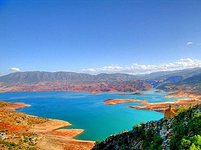
| Bin El Ouidane reservoir | ||||
Bin El Ouidane ( Arabic بين الويدان; Central Atlas Tamazight ⴱⵉⵏ ⵍⵡⵉⴷⴰⵏ ) is a small Moroccan town with around 5,000 inhabitants on the north side of the High Atlas in the Béni Mellal-Khénifra region .
Location and climate
The place Bin El Ouidane is about 54 km (driving distance) south of Beni Mellal on the reservoir of the same name at an altitude of about 850 m . The climate is temperate; Rain (approx. 550 mm / year) falls mainly in the winter half-year.
population
| year | 1994 | 2004 | 2014 |
| Residents | 6,098 | 5,721 | 5,421 |
The vast majority of the population are Berbers ; speak Central Atlas Tamazight and Moroccan Arabic . The slight population decline in the last few decades is primarily due to the migration to the larger cities.
economy
Bin El Ouidane benefits from the nearby reservoir and the connected hydroelectric power station. You can swim in the reservoir itself; Fishing is also allowed.
Attractions
The small town does not offer any historical sights.
Surroundings
The Ouzoud waterfalls ( Cascades d'Ouzoud ) , located approx. 54 km southwest at an altitude of 1068 m , are the largest waterfalls in Morocco and are popular with locals. The Aït Bougoumez valley, about 60 to 100 km south, with the villages of Timit , Tabant , Ibakliwin and others, offers diverse insights into the life of the Berbers in the High Atlas.


