Birgden III
|
Birgden III
City of Remscheid
Coordinates: 51 ° 12 ′ 8 ″ N , 7 ° 12 ′ 15 ″ E
|
||
|---|---|---|
| Height : | 209–250 m above sea level NN | |
| Postal code : | 42855 | |
| Area code : | 02191 | |
|
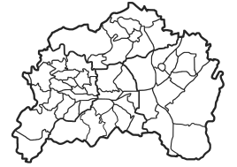
Location of Birgden III in Remscheid |
||
Birgden III is a district in the district of Lüttringhausen in the north of the Bergisch city of Remscheid in North Rhine-Westphalia , Germany . The Roman ordinal number “III” serves to differentiate between two other locations (see Birgden I and Birgden II ) within the city of Remscheid.
Location and description
The settlement stretches from the Leyerbach valley in a northerly direction up the mountain ridge and is located at an altitude between about 209 and 250 meters above sea level . Neighboring villages are Halbach and Farrenbracken . It has around 65 residents in around 27 houses. Birgdener Berg No. 12 is a listed building.
State road 157 runs in the valley and, until it was closed on August 30, 1959, also the route of the Ronsdorf-Müngstener railway that opened on August 21, 1891 . Railway stations were in Stollen and Clarenbach . Today there is a regional bus route (670) between Remscheid and Ronsdorf . Birgden III is located in a rural area, but agriculture no longer plays a role. There have been metal processing companies (including water hammers ) and Kotten in the valley for centuries . Today there are a number of smaller businesses here. In 1937, Max and Ernst Heynen founded the HEYCO tool factory here, the main factory of which is still based here.
history
The court was first mentioned in a document in 1369. At that time it was called "Birckten". In 1815/16 there were 74 residents in the village. In 1832 Birgden was part of the Hohenhagen honors , which belonged to the mayor's office in Lüttringhausen . According to the statistics and topography of the Düsseldorf administrative district , the place called a hamlet had seven residential buildings and four agricultural buildings at that time. At that time 75 people lived in the place, 71 Protestant and four Catholic faith. In the municipality lexicon for the Rhineland province of 1888, ten houses with 88 inhabitants are given.
According to research by Günter Schmidt, the "Birgder Hammer" stood in the Leyerbach valley below the Hofschaft above the Clarenbacher hammers and Kotten. The spelling changed over the years, and so one reads 1439 Byrckden, 1452 Berchde, 1454 Berckden, 1469 Birckde, 1582 Birgkde, Birgte, 1622 Birckden and 1639 Bierden. The Birgder Hammer below Birgden am Leyerbach was built in 1684 and has had various names over the years: Clarenbacher Hammer (1807), Altenas Hammer, Schneider's Hammer, 1. Goldenbergs Hammer , most recently Birgder Hammer.
From 1841 the name was "Goldenbergshammer". The water hammer, which was neglected soon after the turn of the century, was named "Schneider hammer" after the last owner. Even then, at least by Schneider's successors, tools were made in the hammer and tools were ground until after the First World War. Then the hammer fell into disrepair. The pond was a fish pond until the 1950s. Older maps still show the pond, younger only the pond dams. The footpath to Birgden III can be seen in the old maps as a road, the now wooded valley floor as a swampy meadow.
literature
- Gustav Hermann Halbach: Bergischer Sprachschatz. Remscheid 1951.
- Hans Kadereit: Wherever there is still a celebration, coiling and pounding. a historical illustrated book Lüttringhausen, RGA-Buchverlag, Remscheid 2009, ISBN 978-3-940491-07-7 .
- Günther Schmidt: Hammer and Kotten research in Remscheid , Volume 4 - Leyerbach, Diepmannsbach, Mückenbach
Individual evidence
- ^ Johann Georg von Viebahn : Statistics and topography of the administrative district of Düsseldorf. 1836.
- ^ Community encyclopedia for the province of Rhineland. Based on materials from the census of December 1, 1885 and other official sources, edited by the Royal Statistical Bureau. In: Royal Statistical Bureau (Hrsg.): Community encyclopedia for the Kingdom of Prussia. tape XII , 1888, ZDB -ID 1046036-6 ( digitized version ).


