
Blauer Berg (Oberschoderlee)

The Blaue Berg southeast of Oberschoderlee in the Mistelbach district in Lower Austria is home to a dry grassland exposed to the southwest with remarkable dry Pannonian vegetation of national importance. One of the only two occurrences of the European horned melde ( Krascheninnikovia ceratoides ) in Austria is located on this dry grassland .
Geography and geology
The Blue Mountain is a roughly north-south running, at the highest point 284 m above sea level. A. measuring terrain train. To the east, the terrain slopes gently and, as is typical for the Weinviertel , shows intensive arable farming . To the west or south-west the mountain breaks off abruptly and with a slope of over 60% in the form of a loess slope. At the foot of this embankment there is a valley that extends from the village of Oberschoderlee to the southeast towards the Haslerberg and in which the Gießbach rises, which flows a little further north into the Pulkau .
From a geological point of view, the area around Oberschoderlee belongs to the Laa formation from the Carpathian Mountains . On the Blauer Berg, a steep slope covered with loess was created during the last ice age by soil flow . The position exposed to the wind allowed the loess to appear openly in many cases and, together with the steep slope, prevented a closed vegetation cover and led to the formation of a steppe substrate. This only allowed drought specialists to settle the place permanently.
Flora and fauna
The greatest botanical rarity of the Blauer Berg is the European Hornmelde, a species from the foxtail family , which occurs mainly on the upper edge of the slope and also partly on the open parts of the embankment. The horned melde is a sturdy, upright growing and mostly 50 to 100 centimeter high subshrub with inconspicuous, greenish flowers that appears gray-tomentose due to dense star hairs . The flowering time is from August to September. The current main distribution area of the species is in the cold mountain steppes of Central and East Asia . During and immediately after the last Ice Age, there were extensive cold steppes in Central Europe and thus suitable habitats for the Hornmelde. It is believed that this enabled the species to spread to the edge of the glaciated parts of the Alps . After the temperatures rose, it was again displaced by more demanding species and could only hold its own in a few, extremely dry locations, such as the Blue Mountain. Definitive proof that the Hornmelde is an ice age cold steppe relic is still pending. While Gustav Wendelberger described the Hornmelde in 1971 as “one of the oldest relics of the Pannonian region”, in 1890 Günther Beck considered it “probably only brought in from the Orient” due to the ruderal locations . In Austria today occurrences of the Hornmelde are only known at the Blauer Berg and near Goggendorf and the species is considered endangered.
In addition to the horned horn, the loess dandelion ( Taraxacum serotinum ) and the sparrow's tongue ( Thymelaea passerina ) are highly endangered species . As an endangered species that occur on the Blue Mountains, are Summer Adonis ( Adonis aestivalis ), Rosa Gallica ( Rosa gallica ), Austria-Astragalus ( Astragalus austriacus ) lappula squarrosa ( Lappula squarrosa ) Longspine detention umbel ( Caucalis Platycarpos subsp . platycarpos ), Pannonian real yarrow ( Achillea pannonica ) and Valais fescue ( Festuca valesiaca ). In terms of plant sociology, the loess slope was assigned to the “Salvio nemorosae-Festucetum rupicolae” or the “Astragalo exscapi-Crambetum tatariae”, that is, to the continental dry grassland. Starting at the foot of the slope, the dry grassland was gradually settled by locust trees and partially destroyed after the classic land use or grazing was abandoned in the 20th century .
From a faunistic point of view, 27 butterfly species , 8 of which are on Austria's Red List , 23 grasshopper species , 7 of which are on Austria's Red List, the European praying mantis and 39 bird species , including the bee-eater and the eagle owl , have been detected on the Blue Mountain .
Hazard and protection
The occurrence of Hornmelde on the Blauer Berg was discovered by Pastor Ripper from Stronsdorf and herbarized and documented by the Viennese teacher Teyber in 1906 . In the Austrian dry grass catalog, the Blue Mountain was classified as "nationally important", although it was predicted that it would be destroyed by a settlement by robinia. On October 19, 1987, a part of the area at the summit of the Blue Mountain was declared a natural monument, the explicit purpose of which is to preserve the occurrence of horns. However, due to the lack of care measures, the occurrence remained endangered and black locust trees sometimes penetrated to the top of the slope. The Robinia, like all butterflies , accumulates nitrogen in the soil , fertilizes it and makes it colonizable for common species, which displace the rare, specialized species in a row. However, the steeper sections of the terrain are exposed to strong erosion forces, which prevent settlement by other woody plants apart from the Hornmelde. Robinia and field elm advancing on the slope also show significant damage from drought. In addition to horned marmosets, only annuelle and herbaceous dry grass species seem to be able to thrive in the most extreme places . There is therefore only a threat to horned black locust trees in the lower areas of the slope. A hazard from diffuse nutrient inputs or pesticides from the directly adjacent agricultural areas or from the air has not yet been proven. The loosely dry grassland on the Blauer Berg is better off here than comparable biotopes in the Weinviertel, as it is at the highest point of the mountain and there are no agricultural areas up the slope from which the harmful substances could trickle down.
Around 2006, the Lower Austria Nature Conservation Union carried out a project to improve the nature conservation situation on the Blue Mountain. The aim was to secure the occurrence of the horned marsh, to preserve and promote the dry grassland in the long term and to develop awareness among the local population for the natural treasures lying on their doorstep. As concrete measures were u. a. the occurrence of the horn report was mapped, a floristic and faunistic survey was carried out, maintenance measures, such as the removal of robins, were planned and carried out and communication work carried out. The pushing back of the robinia was already ordered as a special protective measure in the declaration on the natural monument, but was not implemented until the start of the protection project. The establishment of a buffer zone to the agricultural land proposed in the final project report has not yet been implemented.
photos
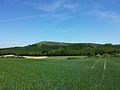
The Blue Mountain seen from the south.

The foot of the mountain is planted with robinia, which eat into the loose dry grass. Hornmelde in the foreground.

View from the steep loosing dry grassland towards the southeast.
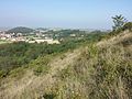
View in northwest direction to Oberschoderlee.

The upper edge of the slope with the occurrence of the Hornmelde, to the right of the path an agricultural monoculture.

Blooming European hornbill ( Krascheninnikovia ceratoides ), endangered in Austria.

Hornmelde inflorescence with a kanker .

Horned, the thick hair is recognizable.

Loess dandelion ( Taraxacum serotinum ), endangered in Austria.

Sparrow's tongue ( Thymelaea passerina ), endangered in Austria.

Long-spiked umbel ( Caucalis platycarpos subsp. Platycarpos ), endangered in Austria.

Common hedgehog ( Lappula squarrosa ), endangered in Austria.


Individual evidence
- ↑ a b Wolfgang Holzner et al .: Austrian dry grass catalog. “Steppes”, “heaths”, dry meadows, poor meadows: existence, endangerment, possibilities of their conservation. In: Green series of the Federal Ministry for Health and Environmental Protection , Volume 6, Vienna 1986, ISBN 3-900-649-065 , Object ÖK 24/6
- ↑ a b c d e f g Margit Gross (coordination): Protection of the Hornmelde in Oberschoderlee, market community Stronsdorf - final report, a project of the Naturschutzbund Lower Austria and the market community Stronsdorf , Vienna 2008 Archive link ( Memento of the original from March 16, 2014 in the Internet Archive ) Info: The archive link was inserted automatically and has not yet been checked. Please check the original and archive link according to the instructions and then remove this notice. (PDF; 4.73 MB)
- ↑ Federal Office for Metrology and Surveying: Austrian Map 1:50 000 , sheet 5307 Haugsdorf, status 2002
- ↑ Geologische Bundesanstalt (Ed.): Geological Map of Lower Austria 1: 200,000, Lower Austria North , Vienna 2002
- ↑ a b Heinz Wiesbauer (Ed.): The steppe lives, rock steppes and dry grasslands in Lower Austria , St. Pölten 2008, ISBN 3-901542-28-0 , p. 63, 69 archive link ( Memento of the original from February 19, 2014 in Internet Archive ) Info: The archive link was inserted automatically and has not yet been checked. Please check the original and archive link according to the instructions and then remove this notice. (PDF; 775 kB)
- ↑ a b Manfred A. Fischer: Relicts of the Ice Age to Early Ice Age Loess Vegetation , in: Heinz Wiesbauer and Herbert Zettel: Hohlwege und Lössterrassen in Niederösterreich , Vienna 2014, ISBN 3-901542-42-6
- ↑ Gustav Wendelberger: From the beginnings of nature conservation in Lower Austria: The early leasehold areas of the Zoological-Botanical Society, A Review in the European Year of Nature Conservation 1970 , in: Negotiation of the Zoological-Botanical Society in Vienna , Vol. 110/111 (1971/1972), P. 133 [1] (PDF; 1.24 MB)
- ↑ a b c d e Manfred A. Fischer, Karl Oswald, Wolfgang Adler: Excursions flora for Austria, Liechtenstein and South Tyrol . 3rd, improved edition. State of Upper Austria, Biology Center of the Upper Austrian State Museums, Linz 2008, ISBN 978-3-85474-187-9 .
Web links
Coordinates: 48 ° 38 ′ 41.3 " N , 16 ° 20 ′ 42.1" E