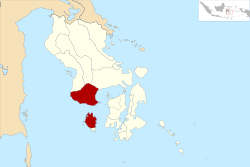
Bombana (administrative district)
| Kabupaten Bombana Bombana Governorate
|
||
|---|---|---|
 |
||
| Symbols | ||
|
||
| Basic data | ||
| Country | Indonesia | |
| province | Sulawesi Tenggara | |
| Seat | Rumbia | |
| surface | 3001 km² | |
| Residents | 143,021 (2019) | |
| density | 48 inhabitants per km² | |
| ISO 3166-2 | ID-SG | |
| Website | bombanakab.go.id (Indonesian) | |
| politics | ||
| Bupati | H. Tafdil | |
Coordinates: 4 ° 48 ′ S , 121 ° 49 ′ E
Bombana is a government district ( Kabupaten ) in the southeast of the Indonesian island of Sulawesi . The district is part of the Sulawesi Tenggara Province ( Southeast Sulawesi ).
geography
The county (Body) borders in the northwest on the district Kolaka , on the north by the District Kolaka Timur and in the northeast on the district Konawe Selatan . In the east the Tiworo Strait ( Selat Tiworo ), in the south the Kabaena Strait ( Selat Kabaena ) and in the west the Gulf of Bone ( Teluk Bone ) forms a natural boundary.
The district includes 25 islands, including the island of Kabaena approx. 20 km south , which is divided into 6 districts in the north. In the south, the Talaga Raya district is part of the Buton Tengah district .
At the last census in 2010, 68,868 female and 70,367 male residents were counted, 15,423 lived in urban and 123,812 in rural areas. Bombana has an area of 3,001 km².
Administrative division
The Bombana Governorate was established by Law No. 29 at the end of 2003. The districts of Rarowatu, Rumbia, Kabaena Timur, Kabaena, Poleang Timur and Poleang were separated from the Buton district. Until 2010, larger districts were divided into smaller ones and currently (2020) there are 22 districts with 143 villages, 15% of these villages have an urban character and are called Keluruhan .
| Territory code code Wilayah |
Kecamatan District |
Capital Ibu kota |
Number of parishes | Area (km²) |
Population 2019 |
Population density (inh / km²) |
|
|---|---|---|---|---|---|---|---|
|
Kelurahan (urban) |
Desa (rural) |
||||||
| 74.06.01 | Poleang | Boepinang | 6th | 4th | 116.18 | 13,701 | 117.9 |
| 74.06.02 | Poleang Timur | Bambaea | 2 | 3 | 102.12 | 9,772 | 95.7 |
| 74.06.03 | Rarowatu | Pigeon account | 1 | 8th | 167.25 | 6.210 | 37.1 |
| 74.06.04 | Rumbia | Casipute | 4th | 1 | 59.19 | 11,225 | 189.6 |
| 74.06.05 | Kabaena | Teomokole | 2 | 2 | 104.37 | 3.119 | 29.9 |
| 74.06.06 | Kabaena Timur | Donghkala | 2 | 5 | 123.91 | 7,030 | 56.7 |
| 74.06.07 | Poleang Barat | Rakadua | 11 | 331.28 | 11,592 | 35.0 | |
| 74.06.08 | Mata Oleo | Lora | 11 | 109.39 | 6,758 | 61.8 | |
| 74.06.09 | Rarowatu Utara | Aneka Marga | 1 | 7th | 188.67 | 6,770 | 35.9 |
| 74.06.10 | Poleang Utara | Toburi | 8th | 237.34 | 10,561 | 44.5 | |
| 74.06.11 | Poleang Selatan | Waemputang | 5 | 90.13 | 6,754 | 74.9 | |
| 74.06.12 | Poleang Tenggara | Larete | 5 | 133.93 | 3,996 | 29.8 | |
| 74.06.13 | Kabaena Selatan | Batuawu | 4th | 131.26 | 3,184 | 24.3 | |
| 74.06.14 | Kabaena Barat | Baliara | 1 | 4th | 47.16 | 7,189 | 152.4 |
| 74.06.15 | Kabaena Utara | Tedubara | 6th | 128.80 | 3,932 | 30.5 | |
| 74.06.16 | Kabaena Tengah | Lengora | 7th | 278.28 | 3,868 | 13.9 | |
| 74.06.17 | Kep. Masaloka Raya | Masaloka | 5 | 2.80 | 2,399 | 856.8 | |
| June 74, 2018 | Rumbia Tengah | Po Ea | 3 | 2 | 21.34 | 6,732 | 315.5 |
| June 74, 2019 | Poleang Tengah | Mulaeno | 4th | 30.74 | 3,594 | 116.9 | |
| 74.06.20 | Tontonunu | Tongkoseng | 5 | 142.32 | 5.134 | 36.1 | |
| 74.06.21 | Lantari Jaya | Lantari | 9 | 373.40 | 7,898 | 21.2 | |
| 74.06.22 | Mata Usu | Kolombi Mata Usu | 5 | 441.14 | 1,603 | 3.6 | |
| 74.06. Bombana | Rumbia | 22nd | 121 | 3,001.00 | 143.021 | 47.7 | |
Source of the administrative and area data: Peraturan Menteri Dalam Negeri RI Nomor 72 Tahun 2019 (ordinance of the Minister of the Interior of October 2019):
The population data are based on updates by the regional civil registration offices and are from the end of 2019.
Web links
- E-books on the statistics page of the district (BPS - Badan Pusat Statistics Kabupaten Bombana) (Indonesian / English)
- Administrative map of the district at a scale of 1: 195,000 (Indonesian)
Individual evidence
- ↑ Sensus Penduduk 2010
- ↑ UU No.29 TH 2003 E-Book (PDF)
- ↑ a b Visualisasi Data Kependudukan , clickable map
- ↑ Peraturan Menteri Dalam Negeri RI Nomor 72 Tahun 2019 E-Book (PDF) page 3146, 3273/3274
