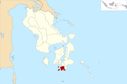
Buton Selatan (Government district)
| Kabupaten Buton Selatan South Buton Governorate
|
||
|---|---|---|
 |
||
| Symbols | ||
|
||
| Basic data | ||
| Country | Indonesia | |
| province | Sulawesi Tenggara | |
| Seat | Batauga | |
| surface | 50,992 km² | |
| Residents | 98,582 (2019) | |
| density | 1.9 inhabitants per km² | |
| ISO 3166-2 | ID-SG | |
| Website | butonselatankab.go.id (Indonesian) | |
| politics | ||
| Bupati | Agus Feisal Hidayat | |
Coordinates: 5 ° 41 ′ S , 122 ° 43 ′ E
Buton Selatan (German: Südbuton) is a government district ( Kabupaten ) on the Indonesian island of Sulawesi . The district is part of the Sulawesi Tenggara Province (Southeast Sulawesi).
geography
The administrative district is located in the extreme southeast of the island of Sulawesi and borders the city ( Kota ) Bau Bau in the north and the Buton district in the west. The natural border in the east and south forms the Floresee ( Laut Flores ). The island of Batu Atas (9.19 km²) is located about 50 km south of the island of Buton and is separated from it by the Banda Sea ( according to Banda ).
Administrative division
The district of Buton Selatan was separated from the district of Buton by Law No. 16 in 2014 and consists of seven administrative districts ( Kecamatan ) (as of 2019):
| Territory code code Wilayah |
Kecamatan District |
Capital Ibu kota |
Number of parishes | Area (km²) |
Population 2019 |
Population density (inh / km²) |
|
|---|---|---|---|---|---|---|---|
| Kelurahan (urban) |
Desa (rural) |
||||||
| 74.15.01 | Batauga | Laompo | 7th | 5 | 151.85 | 17,983 | 118.4 |
| 74.15.02 | Sampolawa | Mambulu | 3 | 13 | 215.73 | 24.205 | 112.2 |
| 74.15.03 | Lapandewa | Lapandewa | 7th | 86.95 | 9,886 | 113.6 | |
| 74.15.04 | Batu Atas | Ujung | 7th | 12.88 | 12,714 | 987.1 | |
| 74.15.05 | Siompu Barat (West Siompu) | Molona | 8th | 16.48 | 11,244 | 682.2 | |
| 74.15.06 | Siompu | Biwinapada | 10 | 37.72 | 11,334 | 300.4 | |
| 74.15.07 | Kadatua | Kaofe | 10 | 24.81 | 11,216 | 452.0 | |
| 74 | Kabupaten Buton Selatan | Batauga | 10 | 60 | 509.92 | 98,582 | 193.3 |
Source of the administrative and area data: Peraturan Menteri Dalam Negeri RI Nomor 72 Tahun 2019 (Ordinance of the Minister of the Interior of October 2019):
The population data are based on updates by the regional civil registration offices and are from the end of 2019
Web links
- E-books on the district's statistics page (BPS - Badan Pusat Statistics Kabupaten Buton Selatan) (Indonesian / English)
- 1: 75,000 scale administrative map of the district (Indonesian)
Individual evidence
- ↑ UU No. 16 TH 2014
- ↑ Kementerian Dalam Negeri - Dukcapil - Visualisasi Data Kependudukan
- ↑ Peraturan Menteri Dalam Negeri RI Nomor 72 Tahun 2019: page 3146, 3276
- ↑ Visualisasi Data Kependudukan , clickable map
