Bonnechere River
|
Bonnechere River Bonnechère River, Rivière Bonnechère |
||
|
Bonnechere River in Renfrew at low tide |
||
| Data | ||
| location | Nipissing District , Renfrew County in Ontario, Canada | |
| River system | Saint Lawrence River | |
| Drain over | Ottawa River → Saint Lawrence River → Atlantic Ocean | |
| source | McKaskill Lake in Algonquin Park 45 ° 44 ′ 41 ″ N , 78 ° 3 ′ 33 ″ W |
|
| Source height | 366 m | |
| muzzle | near Castleford in the Ottawa River Coordinates: 45 ° 31'11 " N , 76 ° 33'27" W 45 ° 31'11 " N , 76 ° 33'27" W. |
|
| Mouth height | 70 m | |
| Height difference | 296 m | |
| Bottom slope | 2 ‰ | |
| length | 145 km | |
| Catchment area | 2400 km² | |
|
Renfrew Museum on the Bonnechere River in Renfrew |
||
|
Location of the Bonnechere River |
||
The Bonnechere River (also Bonnechère River or French Rivière Bonnechère ) is a right tributary of the Ottawa River in the east of the Canadian province of Ontario .
The river has its origin in Algonquin Park . From there it flows in a southeast direction through Renfrew County , before meeting the Ottawa River east and north of Renfrew . The river has a length of 145 km and a catchment area of 2,400 km².
During the 19th century, the river was used to transport Weymouth pine tree trunks from the surrounding wooded areas. Several hydropower plants are located along the river.
The limestone Bonnechère Caves are on the river near the settlement of Eganville at Hamlet Fourth Chute .
The First Chute ("first waterfall") is located at the point where the Bonnechere River meets the Ottawa River, near Castleford.
The second chute is in Renfrew; At this waterfall there is a small dam that belongs to a hydroelectric power plant.
The third chute is in Douglas ; here is also a hydroelectric power station.
The Fourth Chute is located near the hamlet of the same name, Fourth Chute.
The Fifth Chute finally located in Eganville .
The Bonnechere River's tributaries include:
The Bonnechere River flows through Golden Lake and Round Lake . There are two provincial parks along the river: the Bonnechere River Provincial Park (a 23 km section that borders Algonquin Park) and Bonnechere Provincial Park (located on Round Lake).
It is believed that the river name derives from the French term "bonne chère" synonymous with "good food", which could indicate that the early explorers found an abundance of wildlife in the region.
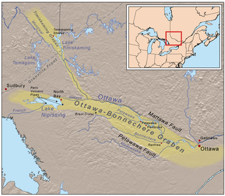
The Bonnechere River flows largely within the 175 million year old rift zone of the Ottawa-Bonnechere Trench .
Rafting race
Every year a rafting race is held on the river between the third and fourth waterfalls . Originally the event was organized by local shriners . The race now has an unofficial status - with little organization. It always takes place on the weekend before Victoria Day . The participants build their own rafts or rafts. The river presents natural obstacles such as easy rapids. The race is not competitive and has been going on for more than ten years.
See also
- Madawaska River - neighboring river with similar characteristics
Web links
Individual evidence
- ↑ a b Bonnechere Museum - Bonnechere River ( Memento of the original from July 6, 2011 in the Internet Archive ) Info: The archive link has been inserted automatically and has not yet been checked. Please check the original and archive link according to the instructions and then remove this notice.


