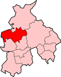
Borough of Wyre
| Borough of Wyre | |
|---|---|
 Location in Lancashire |
|
| status | Borough |
| region | North West England |
| Administration County | Lancashire |
| Administrative headquarters | Poulton-le-Fylde |
| surface | 282.55 km² (162.) |
| Residents | 110,900 (197.) |
| ONS code | 30UQ |
| Website | www.wyrebc.gov.uk |
Wyre is an administrative district with borough status in the county of Lancashire in England . The administrative seat is the city of Poulton-le-Fylde ; other significant places are Catterall , Fleetwood , Garstang , Great Eccleston , Pilling , Preesall and Thornton Cleveleys .
The district was formed on April 1, 1974 and was created from the merger of the Municipal Borough Fleetwood, the Urban Districts Poulton-le-Fylde, Preesall and Thornton-Cleeveleys and the Rural District Garstang.
Web links
Commons : Borough of Wyre - collection of pictures, videos and audio files
Coordinates: 53 ° 54 ′ N , 2 ° 49 ′ W