Bortelhorn
| Bortelhorn / Punta del Rebbio | ||
|---|---|---|
|
Hillehorn and Bortelhorn (right), 1970 |
||
| height | 3194 m | |
| location | Switzerland ( Upper Valais ) / Italy | |
| Mountains | Lepontine Alps | |
| Dominance | 4.2 km → Wasenhorn | |
| Notch height | 430 m ↓ Ritterpass | |
| Coordinates , ( CH ) | 46 ° 17 '40 " N , 8 ° 7' 32" O ( 652 936 / 127248 ) | |
|
|
||
| Normal way | Bortelhütten - Bortel Glacier - Southwest Ridge - Bortelhorn - Northwest Ridge - Simplon Pass | |
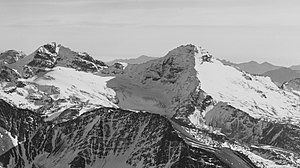
The Bortelhorn (ital. Punta del Rebbio ) is a 3194 m above sea level. M. high mountain of the Lepontine Alps in Switzerland on the Italian-Swiss border ( province Verbano-Cusio-Ossola , Piedmont , in Italy and district Brig , canton Valais , in Switzerland). The small Bortel glacier (2670 to 3060 m ) is located on the western slope . The Bortelsee is an artificial lake that was created from 1987 to 1990 as a head storage for the Bortel power plant . The Bortelhütten is located at 2107 m below the west wall.
Web links
Commons : Bortelhorn - Collection of images, videos and audio files
- Bortelhorn on the ETHorama platform
- Bortelsee at ethorama.library.ethz.ch/de/nod
Individual evidence
- ^ Bortelhorn on the map of the Federal Office for Topography
- ↑ EnBAG (ed.): Bortel power plant . ( enbag.ch [PDF]).


