Breitenfeld (Vienna)
| Breitenfeld | |
|---|---|
| coat of arms | map |

|

|
As one of the youngest suburbs of Vienna, Breitenfeld was a planned village under the manorial rule of the Schottenstift until 1850 and since then has been a district in the Josefstadt district of Vienna . This was managed as the 7th district until 1861, since the original 4th district was divided into the two current districts 4 and 5 as the 8th district.
location
Breitenfeld is located in the northwest of the Josefstadt district and borders
- in the north at Michelbeuern (9th district, Alsergrund ),
- in the west since its construction, 1894–1900, on the Hernalser Gürtel and the 17th district, which was incorporated in 1892, Hernals , Hernals district (before the road was built on the Linienwall ),
- in the south to the district of Josefstadt and
- in the east to the district of Alservorstadt .
The area that belongs to Breitenfeld is bordered by Alser Straße , Hernalser Gürtel, Florianigasse and Feldgasse . In the Historisches Lexikon Wien, Felix Czeike names a narrower delimitation of the Breitenfeld area, which relates to the time before the belt was built: he describes the houses on Bennogasse as the western border.
history

Breitenfeld was founded as the last of the later districts of Josefstadt. In the 15th century and later, the area was a large grain field that belonged to the Schottenstift . It was not until 1801 that the "Obere Alsbreite" (named after the Als , a Wienerwaldbach) was released for settlement by Abbot Benno Pointner , after the neighboring "Untere Alsbreite", the area between Alser Strasse, Skodagasse and Feldgasse, had already been settled in 1770 . The "Untere Alsbreite" was added to the Alservorstadt; the "Obere Alsbreite" was declared a new place Breitenfeld by the manor in 1802. The first three houses were already completed this year, and the settlement was completed by 1830.
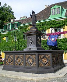
The most famous sponsor of the suburb was Karl Georg Gaber (1771–1854), who headed an educational institute in Alservorstadt, Lange Gasse 20. Gaber was 1802-1812 and 1829-1840 on behalf of the Schottenstiftes Grundrichter von Breitenfeld. In the chronicles he is credited with great services to the rapid development of the place. In 1826 the place was illuminated with 75 lanterns, 1828–1829 the canalization of the area followed. Furthermore, the Isis Fountain was built in 1833 on Gabor's initiative and consecrated in 1834. The official seat of Gabers, built in 1812 (since 1862, Breitenfelder Gasse 10, previously named after Gaber Karlsgasse, or since 1904 Albertplatz 8, previously the main square of Breitenfeld) is still known today as Gaberschlössel . A parish hall was built on the neighboring property (Albertplatz 7) in 1823. From 1824 onwards, a private trivial school was run in Gaber's house at Breitenfelder Gasse 4 , as there was no other school in Breitenfeld; In 1870 the later parish school was taken over by the city of Vienna as a public school. In 1850 the place had 96 houses with 4,875 residents before it was incorporated.
In 1862, various streets were renamed in Vienna in order to avoid the double use of names in the city area. In Breitenfeld, for example, Breite Gasse (also available in the 7th district) was renamed Albertgasse, and Karlsgasse was renamed Breitenfelder Gasse; Königsgasse became Bennogasse (after Abbot Benno Pointner, see above), and Herrengasse (the more prominent of the two existed in the 1st district) became Laudongasse. The Liniengasse, which referred to the Linienwall , which ran here until the 1890s, was made into Blindengasse. The former main square of Breitenfeld was only named Albertplatz in 1904. The names Feldgasse and Florianigasse existed before 1800, Alser Strasse was first mentioned in 1211 (!) (Details: List of street names in Vienna / Josefstadt ).
The church building in Breitenfeld suggested by Gaber did not come about until decades later, since the Archbishop's Ordinariate and the Schottenstift saw no need. The Breitenfeld parish church on the western edge of the former local area (Kirchenplatz, since 1894 Uhlplatz) was consecrated on June 18, 1898 in the presence of Emperor Franz Joseph I , when the place had long since become part of the densely built-up urban area of Vienna. The consecration took place two weeks after the start of operation of the belt line of the Stadtbahn , which runs directly past the church, today's U6 underground line , whose station Josefstädter Straße is just outside of Breitenfeld.
literature
- Christine Klusacek, Kurt Stimmer: Josefstadt. Bars, stages, officials. Vienna 1991 ISBN 3-900272-40-9
- Elmar Mayer (Red.): Parish of Breitenfeld to Saint Francis Seraphikus: 100 years of parish of Breitenfeld 1898-1998 . Parish Breitenfeld, Vienna 1998
Individual evidence
- ^ Felix Czeike : Historical Lexicon Vienna. Volume 1: A – Da. Kremayr & Scheriau, Vienna 1992, ISBN 3-218-00543-4 , pp. 452-453.
Coordinates: 48 ° 12 ′ 51 ″ N , 16 ° 20 ′ 37 ″ E
