
Brelinger Berg
| Brelinger Berg | ||
|---|---|---|
_IMG_6947.jpg) Sand mining on Brelinger Berg |
||
| height | 92 m above sea level NHN | |
| location | at Brelingen ; Region Hannover , Lower Saxony ( Germany ) | |
| Coordinates | 52 ° 34 '17 " N , 9 ° 41' 8" E | |
|
||


The Brelinger Berg is 92 m above sea level. NHN high elevation of the Wedemark landscape in the municipality of Wedemark in the north of the Hanover region in Lower Saxony .
geography
location
The Brelinger Berg rises to the north of the landscape and municipality of Wedemark. In addition to Brelingen , the Wedemärk districts of Abbensen , Duden-Rodenbostel , Oegenbostel , Bennemühlen , Hellendorf and Negenborn are arranged around the elevation. The Great Beeke flows east to north past the elevation and south to west of the Jürsenbach , both of which flow into the Leine .
Natural allocation
The Brelinger Berg belongs in the natural spatial main unit group Weser-Aller-Flachland (No. 62), in the main unit Hannoversche Moorgeest (622) and in the sub-unit North-Hannoversche Moorgeest (622.1) to the natural area Brelinger Berge (622.15). To the south, the landscape turns into the natural area of North Hannoversche Moore (622.14). To the west it falls into the natural area Vesbeeker Talrand (627.16 ) belonging to the subunit Western Aller-Talsande (627.1) and to the north and east into the natural area Hoper Niederungen (627.20) belonging to the subunit Southern Aller-Talsande (627.2), which is part of the The main unit of the Aller Valley Sand Plain (627) is.
geology
The Brelinger Berg was piled up by the glacier ice of the Saale Ice Age about 230,000 years ago to form a compression moraine from the Rehburg phase.
Protected areas
On the Brelinger Berg lies the landscape protection area Brelinger Berge ( CDDA no. 320078; designated 1967; 9.845 km² in size). There is also an approximately 5 hectare site of the NABU Wedemark. On this relatively moist area, which was used for sand and gravel extraction until the mid-1970s, the flora and fauna should be offered a retreat of natural origin.
Others
The intensive sand and gravel mining in the entire area of the Brelinger Berg has left deep traces in the landscape, which are to be returned to nature through gradual renaturation .
The project " Moving Stones - an Ice Age Adventure Trail" was started in 2008 with the first station and presented to the public. It was the contribution of the municipality Wedemark to the campaign year "Garden Region 2009".
A Gauss stone at the highest point at 92 meters is reminiscent of the land survey carried out there in 1828 by the mathematician and geodesist Carl Friedrich Gauß .
gallery

Sand mining and gravel lake on the elevation near Oegenbostel

Kiesteich near Brelingen

NABU transformer tower

Sculpture "Moving Stone" near Bennemühlen
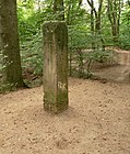
Gauss stone on the highest point of the mountain


literature
- Verena and Volker Stahnke (text): Brelinger Bergwald. In Silke Beck, Susanne Wildermann, Birgit Roos, Burkhard Wetekam (Red.): 12 green treasures. Discovery tours for children in the city and region of Hanover , for children between 5 and 12 years, publisher: Wissenschaftsladen Hanover eV in cooperation with the state capital Hanover and the Hanover region, Hanover: Transfer-Medien, 2013, ISBN 978-398-14315-5 -1 ; Table of contents and publisher's announcement ( Memento of May 5, 2015 in the Internet Archive ), pp. 78–87
Web links
- Ice Age compression in the Brelinger Mountains as a description with photos and map by the State Office for Mining, Energy and Geology in Lower Saxony, (PDF; 219 kB)
Individual evidence
- ↑ a b c Map services of the Federal Agency for Nature Conservation ( information )
- ↑ Project: Trafoturm , NABU Group Wedemark, on nabu-wedemark.de
- ↑ The Ice Age Adventure Trail in Wedemark , accessed on October 31, 2015, at brelingerberge.de