Brewton, Alabama
| Brewton | |
|---|---|
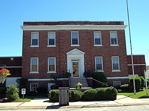
 Old Town Hall in the Brewton Historic Commercial District (2014) |
|
| Location in County and Alabama | |
| Basic data | |
| Foundation : | 1861 |
| State : | United States |
| State : | Alabama |
| County : | Escambia County |
| Coordinates : | 31 ° 7 ′ N , 87 ° 4 ′ W |
| Time zone : | Central ( UTC − 6 / −5 ) |
| Residents : | 5,408 (as of 2010) |
| Population density : | 184.6 inhabitants per km 2 |
| Area : | 29.7 km 2 (approx. 11 mi 2 ) of which 29.3 km 2 (approx. 11 mi 2 ) are land |
| Height : | 25 m |
| Postcodes : | 36426-36427 |
| Area code : | +1 251 |
| FIPS : | 01-09208 |
| GNIS ID : | 0159700 |
| Website : | www.cityofbrewton.org |
| Mayor : | Yank Lovelace |
Brewton is a city and county seat of Escambia County in the state of Alabama in the United States .
geography
Brewton is located in southern Alabama in the southern United States. It is located approximately 14 miles west of 339 square kilometers Conecuh National Forest and just under 4 kilometers north of the Florida border . About 2 kilometers south of the urban area is an exclave with the city's own airport. One kilometer south runs the Conecuh River , which later flows into the Gulf of Mexico .
Nearby places include East Brewton (immediately southeast), Pollard (6 km southwest), Flomaton (12 km southwest), Jay (14 km south), Castleberry (14 km north) and Century (16 km southwest). The next larger city, with 195,000 inhabitants, is Mobile, about 90 kilometers to the southwest .
history
The town was established as a train station in 1861 under the direction of Edmund Troupe Bruton, at that time it was still known as Crossroads , later as Newport . The local economy was destroyed in the course of the civil war, but it was rebuilt by the returnees after the war. About 500 people lived here at the time. An increased demand for lumber drove the economy in the 1870s, as did the central location for rail traffic, which made the city a trading center. Some of the early lumber companies, such as TR Miller Mill founded in 1848 , are still in operation today.
A post office was opened in 1869. In 1885 Brewton was incorporated and a little later appointed to the county seat. In the following year, a fire destroyed large parts of the city. In 1906 the Brewton Standard was founded, which is still the most important local newspaper today.
One location in Brewton is listed on the National Register of Historic Places , the Brewton Historic Commercial District .
traffic
US Highway 29 runs in the south of the city, and US Highway 31 and Alabama state Route 3 run along the same route from south to north . Alabama State Route 15 also ends at an intersection in the south of the city .
Brewton Municipal Airport is located about 2 kilometers south of the city in an exclave .
Demographics
The 2000 census showed a population of 5,498, divided into 2,216 households and 1,471 families. The population density was 187 people per square kilometer. 57.6% of the population were white, 40.2% black, 0.5% Asian and 0.4% Indian. 0.5% were of a different ethnicity , 0.7% had two or more ethnicities, and 1.1% were Hispanics or Latin Americans of any ethnicity. For every 100 women there were about 85 men. The median age was 42 years and the per capita income was 18,185 US dollars, which is about 16.3% of the population below the poverty line .
By the 2010 census , the population had dropped to 5,408.
Personalities
- Hank Locklin (1918-2009), country singer
Individual evidence
-
↑ Search mask database in the National Register Information System. National Park Service , accessed November 14, 2019.
Weekly List on the National Register Information System. National Park Service , accessed November 14, 2019.
Web links
- Official website (English).
- Statistical data on Brewton (Engl.)
- Brewton in the Encyclopedia of Alabama (Engl.)
