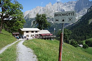
Brochhütte
| Brochhütte | ||
|---|---|---|
|
Broch hut with angel horns |
||
| location | Rosenlaui ; Canton of Bern , Switzerland ; Talort: Schattenhalb | |
| Mountain range | Bernese Alps | |
| Geographical location: | 653 581 / 170164 | |
| Altitude | 1499 m above sea level M. | |
|
|
||
| owner | SAC Oberhasli | |
| Built | 1931, 1993, 2014 | |
| Construction type | hut | |
| Usual opening times | all year round | |
| accommodation | 43 beds, 0 camps | |
| Web link | official homepage | |
| Hut directory | SAC | |
The Brochhütte is a refuge of the Oberhasli section of the Swiss Alpine Club (SAC). It is located in the Reichenbachtal above Meiringen between Rosenlaui and Schwarzwaldalp at 1499 m in the area of the community of Schattenhalb in the Bernese Oberland .
history
The hut was originally a building shack in the Grimsel area for the workers of the Oberhasli power plants (KWO). In 1931 the SAC Oberhasli section bought the accommodation for 4200 francs and transported it, dismantled into individual parts, to its present location, where it was reassembled as a brochure hut. In 1993 it was rebuilt.
In summer 2014 the hut was renovated and modernized. The original structural character was retained and there was still no power connection.
The hut offers 43 beds with duvets in 2 to 20-bed rooms and a family room with 6 beds. The sanitary facilities are integrated in the house.
The Brochhütte is suitable for school classes, seminars, bikers, hikers, families and senior citizens.
Accesses
- The hut can be reached on foot in around 10 minutes from the Schwarzwaldalp. The Postbus drives from Meiringen four times a day to the Schwarzwaldalp.
hikes
- Romantic path: Schwarzwaldalp-Grossen Scheidegg-Oberläger-detour to Hornseeli-Pfanni-Broch-Schwarzwaldalp. Hiking time 4–5. Suitable for families.
- Hike in the Rosenlauital (Haslital) via Schwarzwaldalp to Grosse Scheidegg with a detour to the Rosenlaui glacier gorge ( UNESCO World Heritage ). Difficulty level T2.
- Reichenbach Falls and Aare Gorge (T2)
- Rosenlaui Glacier Gorge - Engelhornhütte - Chaltenbrunnen (T3)
- Rosenlaui - Dossenhütte - Innertkirchen (Alpine hiking T4)
- Wetterhorn Trek: challenging alpine hut tour (T2 to T4) from the Glecksteinhütte to the Broch, Dossen and Gaulihütte.
- Alpbach Gorge (blue-white path, T4)
Adjacent huts
- Engelhornhütte ( 1901 m ), in 1 ½ hours from Rosenlaui (T3).
- Dossenhütte ( 2666 m ), on the blue and white marked alpine footpath in approx. 4 hours (T4).
- Gaulihütte ( 2205 m )
- Glecksteinhütte ( 2317 m )
summit
- Wildgärst 2891 m , from the south via Pass Wart ( 2705 m ) as a hike (T3) or ski tour (L)
- Engelhörner , climbing area
literature
- National map of Switzerland 1: 50,000, sheet 254 Interlaken. Federal Office for Topography, Wabern 2015, ISBN 978-3-302-00254-5 .
Web links
- Brochhütte: Homepage
- Thuner Tagblatt from May 12, 2011: The new hut warden is also a carpenter
- Berner Zeitung of January 27, 2014: Change of plan creates more space in the Brochhütte

