Bundara River
| Bundara River | ||
|
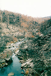
Bundara River. View upstream from the bridge on the Omeo Highway north of Anglers Rest |
||
| Data | ||
| location | Victoria , Australia | |
| River system | Murray River | |
| Drain over | Big River → Mitta Mitta River → Murray River → Indian Ocean | |
| source | south of Mount Bundara in the Alpine National Park 36 ° 57 ′ 0 ″ S , 147 ° 14 ′ 0 ″ E |
|
| Source height | 1420 m | |
| muzzle |
Big River Coordinates: 36 ° 58 ′ 43 " S , 147 ° 29 ′ 39" E 36 ° 58 ′ 43 " S , 147 ° 29 ′ 39" E |
|
| Mouth height | 650 m | |
| Height difference | 770 m | |
| Bottom slope | 25 ‰ | |
| length | 30.2 km | |
| Left tributaries | High Plains Creek | |
| Right tributaries | Emu Creek | |
The Bundara River , formerly also Bundara Mungee River or Bundarah River, is a river in Gippsland in the east of the Australian state of Victoria .
course
It rises east of Mount Hotham and Mount Loch in the Australian Alps and flows east-southeast. It flows into the Big River about two kilometers north of the Anglers Rest settlement .
Tributaries with mouth heights
- High Plains Creek - 1,225 m
- Emu Creek - 731 m
They arise on the southern slopes of Mount Jim (1,818 m), Mount Bundara (1,741 m) and Mount Cope (1,837 m), as well as from the hills east of the main ridge of the Australian Alps.
Water quality
The Bundara River and its tributaries are protected in the national park. Most of the watercourses in the Mitta-Mitta Basin are rated as having good to excellent water quality. Extensive forests cover most of their catchment areas. Despite minor deforestation and minor damage to the river banks by livestock, the quality of the river habitat is generally quite good.
The Bundara River is considered to be good fishing waters, especially for brown trout . The river is governed by the North East Catchment Management Authority's Victorian River Health Program .
In early 2003, large forest areas on the Bundara River and its tributaries were affected by extensive forest fires. Thousands of square kilometers of bushland burned for almost two months. The damage to the vegetation had an impact on the water quality of the river for a long time.
See also
Web links
Individual evidence
- ↑ a b c d Map of Bundara River, VIC . Bonzle.com
- ↑ Place details . In: VICNAMES the Victorian Register of Geographic Names . Victorian Government, Department of Sustainability and Environment. Archived from the original on March 10, 2012. Retrieved April 12, 2011.
- ↑ a b VicRoads Country Street Directory of Victoria , 4th Edition, Royal Automobile Club of Victoria, Noble Park (Victoria) in 2000, ISSN 1329-5284 (Accessed on April 12, 2011).
- ↑ a b A guide to inland angling waters of Victoria: Mitta Mitta basin . In: Department of Primary Industries website . Government of Victoria (Australia), State Government of Victoria. January 11, 2011. Archived from the original on March 17, 2011. Retrieved on April 11, 2011.
- ^ No end in sight for Victorian bushfires . In: The Age , January 27, 2003. Retrieved December 29, 2010.
- ↑ Tom Noble: Razing Heaven . In: The Age , February 2, 2003. Retrieved December 29, 2010.

