Montbrun Castle (Dournazac)
| Château de Montbrun | ||
|---|---|---|
|
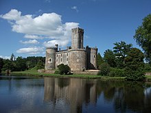
Montbrun Castle, taken from the southwest |
||
| Creation time : | 12th and 15th centuries | |
| Castle type : | Niederungsburg | |
| Conservation status: | Preserved essential parts | |
| Place: | Dournazac | |
| Geographical location | 45 ° 38 '10 " N , 0 ° 53' 53" E | |
| Height: | 341 m | |
|
|
||
The Monbrun Castle ( French Château de Montbrun ) is a 12th and 15th century castle in the municipality of Dournazac ( Haute-Vienne , Nouvelle-Aquitaine region ) .
geography
The castle lies at an altitude of 341 meters in the valley of Le Dournaujou , a small right tributary of the Dronne . It comes down from the Grand Puyconnieux (498 meters) to the south and is dammed up together with a smaller right branch at the castle for defensive purposes. The D 94 from Dournazac to La Chapelle-Montbrandeix leads directly past the castle area. The center of Dournazac in the southeast is only 1.7 kilometers away.
geology
The castle stands on highly metamorphic eye gneisses of the lower gneiss cover of the Limousin . These crystalline rocks of the northwestern Massif Central are foiled . Its foliation level strikes north-north-west and falls at around 40 degrees to east-north-east. Recognizable stretching lines descend at 20 to 30 degrees to the east-southeast. The original rocks of the Augengneise were probably granite porphyries or very immature arcoses .
description
Even if the complex has numerous elements of a typical castle, it was designed primarily as a pleasure palace . It has a Romanesque donjon , which was equipped with machicolations in the 14th century . The main building dates from the 15th century. Its four corners are reinforced with mighty round towers. The sides are equipped with large cross- frame windows, which were difficult to defend in an emergency.
The Montbrun Castle is one of the sights for the Communauté de communes des Monts de Châlus and the Regional Nature Park Périgord-Limousin . In the miniature park France miniature near Paris, its model represents the Limousin along with three other objects .
history
The place on which the castle now stands was inhabited since the 11th century. This is evidenced by a high moth located right next to today's castle . Pierre Brun, then lord of Montbrun, commanded the garrison of Châlus together with the knight Pierre Basile in 1199 , when it was besieged by Richard the Lionheart - but who was killed here.
In the 12th century a stone castle was built, the Romanesque donjon of which is still preserved. This facility was burned down and almost completely rebuilt later in the 15th century. During the French Revolution , the castle was captured and looted , but restored again in the following 19th century . After another fire in 1917, the castle was completely restored.
Since 1995 the castle complex has been inhabited by the Dutchman Maarten Joost Lamers, who is continuing the repair work.
The interior of the castle has been inscribed as a Monument historique since September 20, 1946 , followed by the outer area with the associated parcels on April 10, 1990.
Individual evidence
- ↑ Bernard Briand and others: Châlus . In: Carte géologique de la France at 1/50 000 . tape XIX-32 . BRGM.
- ^ André Châtelain: Châteaux forts - Images de pierre des guerres médiévales . Rempart, Paris 2003, ISBN 2-904365-00-1 , p. 50 .
- ↑ Paul Patier: Histoire de Chalus and its region . In: Monograph des villes et villages de France . Paris 1993, ISBN 2-7428-0184-7 .


