
Nidberg Castle (Saxony)
| Nidberg Castle | ||
|---|---|---|
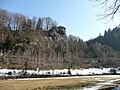
.jpg) View from the east over the outer and main castle, |
||
| Creation time : | around 1150 | |
| Castle type : | Höhenburg, spur location | |
| Conservation status: | Foundations | |
| Place: | Zöblitz | |
| Geographical location | 50 ° 39 '42.5 " N , 13 ° 13' 3.4" E | |
|
||

The castle Nidberg was a medieval Spur castle about 1 km west-northwest of Zöblitz on a westward spur above the Black Pockau . It thus belonged to the spur castle type and was first mentioned around 1150. Only a presumed tower foundation remains from her today .
history
On July 23, 1292, Heinrich, abbot of the Hersfeld Monastery , issued a certificate that Margrave Friedrich von Meißen (the Freid) had requested to consolidate his position in terms of tenancy law. In the document, the Wettiner his rights to the land of the monastery in the central Ore Mountains are confirmed, for which the following boundary description is given:
“The ownership of the Hersfeld Church begins where the Große Striegis rises, along the course of that river to the Mulde and downwards to the Zschopau and the Zschopau up to the old Bohemian Steig, which separates the property (the monasteries) Chemnitz and Hersfeld, and along that path to the Pockau, up the Pockau to Nidberg, which Werner had built, and from the river that flows past Nidberg to the Striegis .... "
In the middle of the 12th century the development of the realm of Pleißen began in the western and central Ore Mountains , with the establishment of which the central authority under Emperor Friedrich Barbarossa attempted to counter the rising sovereignty of the Margraves of Meissen . The settlement of the new soil here was purposefully planned from the Reichsburg Altenburg , on a royal commission. Reichsministeriale directed the conquest and secured political power and economic influence by building castles.
An old long-distance path played a role in the development of the country in the area around Zöblitz, which led from Rochlitz and Chemnitz via Zschopau - Zöblitz - Rübenau to Bohemia and appears in written records as an old Bohemian path . The Hersfeld border description with the mention of the castle is a testimony to the wave of settlements that advanced to the crest of the Ore Mountains shortly after the middle of the 12th century, with the Bohemian climb as the guideline. The ravine at the western end of Schloßbergstraße in Zöblitz, which accompanies the northern flank of the mountain spur with the “lion's head”, can be seen as a section of this long-distance path .
Werner von Neidberg , named as the builder of Nidberg Castle, belongs to the von Erdmannsdorff family of Reich ministers from Pleißenland , who can still be traced in the area around Zöblitz until the turn of the 13th and 14th centuries: 1299 in Forchheim and 1304 in Lauterstein .
Nidberg Castle was the seat of the ministerial office, and its connection with the Bohemian Steig also shows it to be a road protection facility. Together with the Schwedengraben settlement in the valley on the opposite bank of the Schwarzen Pockau , Nidberg formed a castle and settlement complex that is connected to the colonization of the area in the 12th century. This served to protect the path at the transition over the river and to direct the flow of settlers.
In terms of function and importance, it lagged behind Lauterstein Castle , which was roughly the same age and developed into the center of power with a corresponding feudal district. In connection with this, Nidberg may have been given up.
photos
View from northwest to the Löwenkopffelsen in the valley of the Schwarzen Pockau - once the location of the main castle

View from the northeast over the outer and main castle - in the foreground left a presumed tower foundation

Presumed tower foundation in the outer bailey - later built over with a wooden field barn until the end of the 20th century
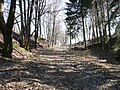
Ravine to the north - once a Bohemian path

.jpg)


literature
- Thomas Gerlach , Wanda Gawlowska: The excavations at the Lauterstein and Nidberg castles near Marienberg in 1977 . In: Ausgrabungen und Funde Vol. 24 (1979) pp. 47-51.
- Volkmar Geupel : The excavations at the Lauterstein and Nidberg castles near Marienberg in 1976 . In: Ausgrabungen und Funde Vol. 23 (1978) pp. 31-37.
- Volkmar Geupel: Mysterious story of the lost Nidberg Castle. In: Erzgebirgische Heimatblätter Vol. 1, No. 1, Marienberg 1979, p. 18 ff ( copy ( Memento of December 21, 2007 in the Internet Archive )).
- Joachim Seyffarth : The enigmatic history of the lost Nidberg Castle . In: The homeland friend for the Ore Mountains . 1972, p. 57 ff.
- F. Geupel: "Nidberg near Zoblitz castle and settlement complex." In: Archaeological field research in Saxony. Berlin, GDR, 1988.
Web links
Individual evidence
- ↑ M. Kästner, J. Schiller: Between Chemnitz and Freiberg. A home book for school and home. 1. The homeland and its settlement . Frankenberg 1928, pp. 36-37.
- ↑ M. Kobuch: The Lauterstein castle ruins . In: Sächsische Gebirgsheimat. Calendar 1978, sheet September 25, 1978.
- ^ Gerhard Billig, Volkmar Geupel: Development, forms and dating of the settlements in the ridge region of the Ore Mountains. In: settlement research. Archeology - History - Geography, Volume 10, Verlag Siedlungsforschung Bonn 1992, S 177. ISSN 0175-0046