
Burkersdorf (Triptis)
|
Burkersdorf
City of Triptis
Coordinates: 50 ° 47 ′ 2 " N , 11 ° 49 ′ 1" E
|
||
|---|---|---|
| Incorporation : | July 1, 1950 | |
| Incorporated into: | Pillingsdorf | |
| Postal code : | 07819 | |
| Area code : | 036481 | |
Location of Burkersdorf in Thuringia |
||
 Church in Burkersdorf
|
||

Burkersdorf is a district of the town of Triptis in the Saale-Orla district in Thuringia .
geography
Burkersdorf is hidden on a plateau surrounded by meadows and fields as well as forest. A local connecting road leads to state road 2318 from Neustadt an der Orla to Lippersdorf . The place Burkersdorf is located northeast of Neustadt an der Orla and northwest of Triptis . The plateau of Burkersdorf belongs to the Saale-Elster sandstone slab. North of this location begins the Thuringian woodland around Hermsdorf and Klosterlausnitz to Eisenberg .
With the KomBus line 832 , Burkersdorf has a connection to the core town of Triptis and the town of Neustadt (Orla) .
history
It was first mentioned in documents in 1378. The hamlet has always been characterized by forest and agriculture. People talk about the neat 12 half-timbered houses on the Heide . Landscape-economy-society are closely linked.
Burkersdorf was incorporated into Pillingsdorf on July 1, 1950. In the meantime Pillingsdorf belonged to the administrative community Triptis. When the municipality of Pillingsdorf was dissolved, Burkersdorf joined Triptis on January 1, 2012.
There was already a church in the Middle Ages .
Individual evidence
- ^ Wolfgang Kahl : First mention of Thuringian towns and villages. A manual. 5th, improved and considerably enlarged edition. Rockstuhl, Bad Langensalza 2010, ISBN 978-3-86777-202-0 , p. 46.
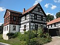
Half-timbered yard in Burkersdorf

Half-timbered house in Burkersdorf

Half-timbered building in Burkersdorf


Web links

Burkersdorf | Döblitz | Hasla | Oberpöllnitz | Ottmannsdorf | Pillingsdorf | Schönborn | Triptis