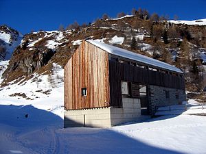
Capanna Bovarina
| Capanna Bovarina UTOE hut |
||
|---|---|---|
| location | Val di Campo ; Canton Ticino , Switzerland ; Valley location: Campo | |
| Mountain range | Lepontine Alps | |
| Geographical location: | 711 175 / 157554 | |
| Altitude | 1870 m above sea level M. | |
|
|
||
| owner | Bellinzona section of the UTOE | |
| Built | 1971, 1997 | |
| Construction type | hut | |
| Usual opening times | June to October | |
| accommodation | 42 beds, 0 camps | |
| Hut directory | DAV SAC | |
The Capanna Bovarina ( German Bovarinahütte ) is a refuge in the village of Campo in Val di Campo in the canton of Ticino in the Lepontine Alps at an altitude of 1748 m above sea level. M.
History and description
The Bovarina hut was inaugurated in 1971 and completely modernized in 1997. It belongs to the Bellinzona section of the Unione Ticinese Operai Escursionisti (UTOE) under the umbrella organization Federazione Alpinistica Ticinese (FAT). The hut has three floors with two dining rooms for a total of 60 people. The kitchen has a wood and gas stove and electric lighting.
On the ground floor there are toilets, showers with hot water (for a fee) and a shoe room with an adjoining drying room. On the first floor there are two lounge and dining rooms with 50 seats, two wood stoves, books, magazines and various games for children. On the upper floor there are four rooms with a total of 42 beds, three of them with 8 beds and one with 18 beds. All beds have Nordic duvets (silk or cotton sleeping bags are compulsory).
There is running water all year round. The hut is particularly suitable for winter courses and youth weeks, even after heavy snowfall. In the absence of the keeper, wood and gas hobs with kitchen utensils are available.
Hut access with walking time
- From the Alpe Predasca ( 1742 m above sea level ) in 30 minutes
- From Campo Blenio ( 1216 m above sea level ) in 2 ½ hours (level of difficulty T2).
- From the Lukmanier Pass ( 1915 m above sea level ) in 2 ½ hours (T2).
The Lukmanier Pass can be reached by public transport during the summer season.
hikes
- Lago Retico ( 2372 m above sea level ) in 1 ½ hour (T2).
- Passo Ganna Negra ( 2463 m above sea level ) in 2 hours (T2)
Ascents
- Cima Bianca ( 2893 m above sea level ) in 3 ½ hours
- Piz di Cadreigh ( 2505 m above sea level ) in 2 ½ hours
- Scopí ( 3178 m above sea level ) in 2 ½ hours
- Cima di Garina ( 2780 m above sea level ) in 3 hours
Transitions to neighboring huts
- Capanna Dötra in 2 ½ hours
- Capanna Cadagno in 4 ½ hours
- Capanna Scaletta in 5 hours
- Capanna Cadlimo in 6 hours
activities
The area just south of the main Alpine ridge is suitable for hiking, trekking, ski and snowshoe tours. The hut is a stopover for treks between the Greina and the region around Lukmanier and Ritomsee .
literature
- Massimo Gabuzzi: Huts and rifugi in Ticino and Misox . Edizioni Salvioni, Bellinzona 2005, ISBN 978-88-7967-123-1
- Chiara Brenna: Ticino e Mesolcina. Guida escursionistica . Edizioni Salvioni, Bellinzona 2003. ISBN 88-7967-081-6 .

