Lago Retico
| Lago Retico | ||
|---|---|---|

|
||
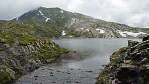
| View from the outflow to the west to the Cima della Bianca | ||
| Geographical location | Blenio , Ticino | |
| Drain | Ri di Scengio → Orsàira → Brenno | |
| Location close to the shore | Campo | |
| Data | ||
| Coordinates | 711 335 / 159456 | |
|
|
||
| Altitude above sea level | 2372 m above sea level M. | |
| surface | 8.5 ha | |
| scope | 1180 km | |
The Lago Retico is a mountain lake at 2372 m above sea level. M. in the Valle di Campo of the Swiss municipality Blenio in the Lepontine Alps . It is located just below the Cristallina pass ( 2398 m above sea level ), over which the main Alpine ridge and the border between the cantons of Ticino and Graubünden runs. The Lukmanier Pass is a few kilometers to the west .
Location and geology
The oval lake lies in a rock hollow at a geological break, created by glacial excavation . On the south bank of Lago Retico there is black Bündner slate and subsequently also light limestone slate, on the north bank striped gneiss .
To the west of the lake are sub-peaks of the Cima della Bianca ( 2893 m above sea level ), in the east the Cima di Garina ( 2780 m above sea level ). Beyond the Cristallina pass in the north, it goes down into Val Cristallina, a side valley of Val Medel . On the south side the terrain drops very steeply into Val di Campo after a small ridge (Karschwelle), which forms the end of the hollow.
fauna
Fish have been released repeatedly in the lake, such as American char in 1977 and brook trout in 1982. Rainbow trout are also released every year .
Origin of name
According to certain sources, the name goes back to an Etruscan guide Reto who, defeated by the Gauls , had to retreat to the Alps.
See also
Web links
- Lago Retico on schweizersee.ch
- Lago Retico on ti.ch
Individual evidence
- ↑ a b c Plinio Grossi, Centro di dialettologia e di etnografia: Mountain lakes of Italian Switzerland . Ed .: Fondo Laghetti alpini della Svizzera italiana. Retico, no. 7 . Bellinzona March 2000 ( Online [PDF; 1.3 MB ]).
- ↑ National map (geo.admin.ch), water network VECTOR25
- ↑ national map (geo.admin.ch), Geological Atlas GA25
