
Celestun
| Celestun | ||
|---|---|---|
|
Coordinates: 20 ° 52 ′ N , 90 ° 24 ′ W Celestún on the map of Yucatán
|
||
| Basic data | ||
| Country | Mexico | |
| State | Yucatan | |
| Municipio | Celestun | |
| Residents | 6810 (2010) | |
| City insignia | ||
|
|
||
| Detailed data | ||
| height | 1 m | |
| Post Code | 97367 | |
.JPG) |
||
 |
||

Celestún is a fishing village in the north of the Mexican peninsula Yucatán on the Gulf of Mexico 90 km west of the old sisal town of Mérida . Celestún is located in the extreme west of the state of Yucatán , has about 6800 inhabitants and is the administrative seat of the Municipio Celestún .
Its name is often used synonymously for the adjacent Biosphere Reserve, Reserva de la biosfera Ría Celestún , a species-rich nature reserve made up of ria , lagoon and mangrove landscapes. The biosphere reserve is known for its high flora and fauna diversity . In the estuary Estero , lives in addition to the deposits in Ria Lagartos, only colony of Cuba flamingos in Mesoamerica . The Celestún mangrove area was declared a UNESCO Biosphere Reserve in 2004 .
topography
The mangrove landscape surrounding the town of Celestún is located to the west of an upstream sand dune on the Gulf of Mexico at sea level.
The water surface of the mangrove swamp is 59,139 hectares. The estuary is 21 km long and up to 3 km wide. To the south is the petrified forest of Tampetén .
Hydrological peculiarities are the freshwater springs Baldiosera and Cambay in the protected mangrove area . The springs serve to supply the local population with fresh water. Swimming is possible in the natural lakes fed by fresh water.
To the west of the lake are the fishing villages of Xixin and Cholul . The estuary is cut by the road bridge on the Mérida highway to the sandy beach of the fishing village of Celestún.
Flora and fauna
Along the mangrove bank you will find flora and fauna unique in the world, rich in species and varieties .
flora
The mangrove forest is made up of evergreen salt plants . Some of these have stilt roots for anchoring in the soft mud . The aerial roots protruding vertically from the brackish water supply the plants with additional oxygen . Thus they adapt to the oxygen-poor soil conditions. The mangrove plants reproduce through viviparous (live-bearing) reproduction. Young plants germinate on the mother plant. Important genera are in Celestún Bruguiera , Rhizophora , Ceriops , Avicennia and Sonneratia . The constant growth of the mangrove plants promote the increasing siltation of the lagoon.
fauna

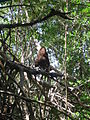
Numerous North American water birds overwinter in Celestún from December to March. The Isla de los pajaros (Bird Island), located in the river mouth, is a preferred breeding place for birds in the Celestún swamp. The creatures in Celestún include fish , shrimp and mussels as well as numerous species of birds such as B. Brown pelican , frigate bird , cormorant , heron , snow ibis and mangrove buzzard . The Cuba Flamingo , a subspecies of the Greater Flamingo , uses the mangrove lake as a resting, feeding and breeding ground.
The 234 mammals found in the mangrove forest of Celestún include ocelots , jaguars and long-tailed cats as well as the threatened Geoffroy's spider monkey . In addition, the mangrove habitat of bump alligator and American crocodile and the Greens and the Loogerhead- turtle .
Numerous insects live in the adjacent low jungle. In particular, subtropical butterflies and termites populate the forest. Shrimp populate the estuary in western Pointe Ninum .
economy
In Celestún, salt was first extracted economically in a salt works . After salt mining was abandoned, only the old salt works and the Real Salias ranch are reminiscent of the former primary production of salt. The area was not used for agriculture. The wide estuary of the Estero river allows shipping with small motor boats in the shallow salt water of the lagoon. Mayan hunters roam the jungle for self- sufficiency with game meat. The estuary is fished by small boats using nets.
Today Celestún is a popular Mexican tourist destination. The departure point for tourist boat excursions is the small Unidad de Servicios dock near the road bridge . Numerous smaller restaurants offer the local population temporary jobs in the travel season.
Environmental influences
Tourism is carried out cautiously and in accordance with the local conditions in an environmentally friendly manner. However, the large population of water birds has led to the destruction of the foliage on the surrounding trees. A savannah landscape has since formed through erosion . The cultivated coconut palms on the offshore sand dune were largely destroyed by herbicide . A fungus-resistant variety was then successfully reforested with the support of the Mexican government.
Picture gallery

Mangrove forest with fresh water source

Frigate birds

Fish in the mangrove

Bridge to Merida
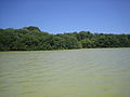
Mangrove lakeshore
Termite mounds in the mangrove

Flamingos and cormorants

Pelicans in the mangroves


literature
- Ortrun fluke weed: Mexico travel guide . Visa Point Verlag Cologne, 3rd edition 2006, p. 161
Web links
- Homepage of Celestún under the government of Yucatán (Spanish)
- Info page of UNESCO (English)